JACKSONVILLE, Fla. — The First Alert Weather Team said there will be fewer storms and more heat this week.
WATCH THE FORECAST | DOWNLOAD THE APPS
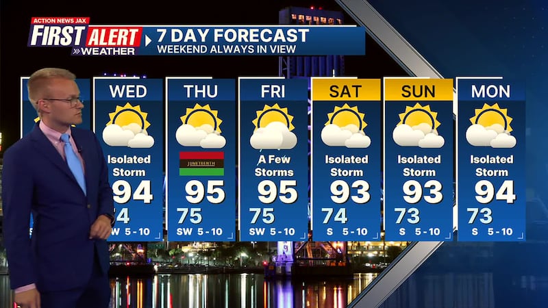
Here’s what you can expect in the Jacksonville area:
- Scattered storms into Monday evening will be heavy in spots as individual storms move E/NE.
- The storms will diminish by or shortly after sunset.
- The general trend this week will be fewer storms and hot/humid temperatures.
- Afternoon highs will be in the 90s with overnight lows in the 70s.
INTERACTIVE RADAR: Keep track of the rain as it moves through your neighborhood
TROPICS: No areas of concern. Always more: “Talking the Tropics With Mike”.
- TONIGHT: Scattered evening storms then partly cloudy. Low: 74
- TUESDAY: Partly sunny with a few afternoon thunderstorms. High: 93
- TUESDAY NIGHT: Becoming mostly clear. Low: 74
- WEDNESDAY: Partly sunny with an isolated afternoon thunderstorm. High: 94
- THURSDAY: Partly sunny with isolated afternoon thunderstorm. 75/95
- FRIDAY: Partly cloudy, a few afternoon thunderstorms. 75/95
- SATURDAY: Partly cloudy with isolated afternoon thunderstorms. 74/93
- SUNDAY: Partly sunny with isolated afternoon showers/thunderstorms. 74/93
- MONDAY: Partly cloudy with isolated afternoon showers/storms. 73/94
Follow Action News Jax Meteorologists on Twitter for updates:
Mike Buresh | Garrett Bedenbaugh | Corey Simma | Trevor Gibbs
ALLERGY TRACKER: See what the pollen counts look like in our area
LISTEN: Mike Buresh ‘All the Weather, All the Time’ Podcast
SHARE WITH US: Send us photos of the weather you’re seeing in your area ⬇️


