
Jacksonville, Fl. — The “Buresh Bottom Line”: Always be prepared!.....First Alert Hurricane Survival Guide... City of Jacksonville Preparedness Guide... Georgia Hurricane Guide.
STAY INFORMED: Get the * FREE * First Alert Weather app
FREE NEWS UPDATES, ALERTS: Action News Jax app for Apple | For Android
WATCH “Preparing for the Storm”
WATCH “The Ins & Outs of Hurricane Season”
READ the First Alert Hurricane Center “Survival Guide”
LISTEN & WATCH “Surviving the Storm” - WOKV Radio & Action News Jax
***** ALWAYS CHECK & RE-CHECK THE LATEST FORECAST & UPDATES! *****
REMEMBER WHEN A TROPICAL STORM OR HURRICANE IS APPROACHING: Taping windows is *NOT* helpful & will not keep glass from breaking.
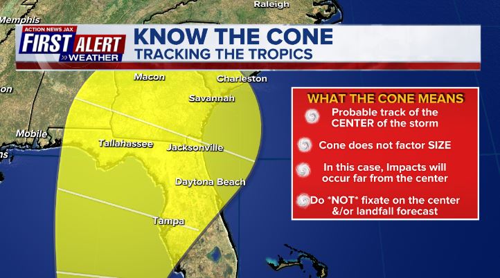
Realize the forecast cone (”cone of uncertainty”) is the average forecast error over a given time - out to 5 days - & *does not* indicate the width of the storm &/or damage that might occur.

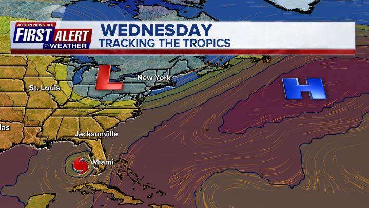
** FIRST ALERT! ** - Anyone living in - or traveling to - Florida & the Southeast U.S. should stay up to date on the latest forecast as Ian moves through the Eastern Gulf of Mexico & then to Florida. A reminder to NOT focus too much on the exact landfall point or intensity forecast. **
One should be careful about determining the threat to life & property based on the category of the storm & whether or not Ian is weakening. Dangerous impacts are imminent for a good part of Fl. It’s possible that the storm surge will be a category or so higher than what one might expect &/or higher than is forecast (in other words, a Cat. 1 might have a Cat. 2 storm surge, etc.).... along with the possible record flooding in some areas.
LOCAL - NORTHEAST FLORIDA/SOUTHEAST GEORGIA - POTENTIAL IMPACTS FROM IAN *BASED ON THE CURRENT FORECAST PATH*:
Tropical Storm WARNING & Storm Surge WARNING for the St. Johns River including downtown Jacksonville....& the coast & intracoastal + inland areas of Duval, St. Johns, Nassau, Clay & Putnam, coastal Camden & Glynn Counties in Ga....tropical storm WATCH for inland Nassau Co., Baker, Bradford & Union Counties in Fl. & inland Camden, Glynn, Charlton & Brantley Co. in Ga.
* The exact timing & intensity of any & all Ian impacts for NE Fl./SE Ga. will be dependent on the exact location & strength of Ian in reference to Jacksonville & will, of course, be subject to change.
* Few if any direct impacts from Ian into Wed. morning.... with the first rainfall - still not necessarily directly a result of Ian (enhanced by onshore flow) - arriving in parts of St. Johns & Putnam Co. through the day Wed. spreading slowly from south to north. Some areas north of I-10 - especially more inland - may have little rainfall through Wed. night into Thursday morning.
* Potential rainfall: 8-12″... 15″+ for some areas with max amounts as high as 20″+! for a few areas south of I-10, near & east of I-95 & near & along the coast. The most extreme rainfall potential will be along & south & east of a line from Brunswick to St. Marys to Bryceville to Macclenny to Lake Butler where the heaviest rain bands are expected to be the most frequent & persistent with a possible possible bullseye over approximately Southeast Duval southward through much of St. Johns Co. & west to Eastern Clay & Eastern Putnam Co. Inland areas - Lake City to Olustee to Baxter to Folkston to Waycross to Nahunta & nearby areas of Ga.: 2-5″, locally 6″+.
Tropical moisture surging north combined with onshore winds (out of the east) ahead of Ian should begin to bring some showers, isolated t’storms from south to north through the day Wed. This will start to saturate the already wet ground across the area leading to flooding issues Thu./Fri. - in particular - as heavy Ian rain bands move across the area & potentially “train” across some areas. The saturated soil may also lead to trees being more easily uprooted by winds that otherwise may not be much of a problem. The local area has dried out some over the past 7-10 days but the very wet Aug./early Sept. has still left soils essentially saturated... + we’re coming off a week of higher than avg. tides partially due to the new moon cycle & astronomically higher than avg. tides, so there’s a good deal of water “in the system” that will be added to in the coming days. The winds out of the east will also help force more water into inlets, the intracoastal, streams & rivers. Flooding along the St. Johns River & its tributaries is likely as well.
We’ll have to keep a close eye on downtown Jacksonville as - given the current forecast & now Ian staying south of Jacksonville before moving northward near the coast - strong easterly flow Thu. into Friday may “pile up” water at the bend near the Acosta Bridge (where it goes from flowing to southwest then south) causing water to overflow into parts of downtown... in addition to the heavy rain & high tidal departures. This situation is different than Irma in 2017 as Irma stayed to the west causing a strong & long fetch of southerly flow up the St. Johns River into downtown Jacksonville. The current Ian forecast is somewhat more similar to Matthew in ‘16 (exception is that Matthew moved parallel & offshore the coast upon approach from the southeast). Those impacted by flooding during either Irma in ‘17 or Matthew in ‘16 should consider alternative shelter & beware of rapidly rising water at any time with the greatest threat from later Thu. through late Fri. into Fri. night. It would appear - with the track south of Jacksonville that downtown Jacksonville would *not* have a repeat of the Irma flooding but could still see significant water levels. The forecast trend for Ian’s center is a good deal more south & east which could help some in that there would not be as long a fetch of winds directly north up the St. Johns River into d’town Jacksonville. However, a long period of strong winds out of the east will compensate - at least some - & make flooding worse for the area east to the coast. The lower reaches of the St. Johns River in parts of Clay & St. Johns Co. will also be subject to some “sloshing” effect which could increase the surge values. And finally.... larger rivers will take longer to crest & may rise through the weekend into next week.
Those along Black Creek & its tributaries in Clay Co. should be aware of the flood threat & be ready to evacuate, if necessary.
* Storm surge is expected to average at least 3-5 feet at the Fl. coast & along the St. Johns River (for comparison, St. Johns River storm surge caused by Irma was 5-6 feet in downtown Jacksonville in Sept., 2017 & was 5-7+ feet during Matthew at the coast in Oct., 2016). It is possible - if everything (heavy rain, high tide, strong east winds) comes together at the wrong time - there *could* be record flooding in some areas. The storm surge forecast is a significant 4-6 feet for the southeast coast of Georgia from St. Marys to St. Simons Island/Jekyll Island & Brunswick.
* Seas & surf will increase through the week. Double digit breakers at local beaches can be expected Thu./Fri. with a very high rip current risk. Breakers at the beaches 5-7+ feet Wed... 10-15+ feet Thu... 8-12+ feet Fri.... subsiding over the weekend but with dangerous rip currents continuing.
* Gusty winds arrive Wed. but increase further Thu./Fri. *At the moment* tropical storm force (39+ mph) sustained winds will be possible in some areas favoring near & south of I-10 with hurricane force (74+ mph) wind gusts possible but only for brief times. Strongest winds will occur south of Highway 16 & east of I-95 including the beaches & along waterways. Keep in mind that bridges are usually closed when sustained winds reach 40 mph but local officials may make “the call” at anytime depending on local conditions & forecasts.
* Isolated waterspouts & tornadoes can be expected Wed. through early Fri.
* At least some power outages should be expected. Realize utility companies will not be able to begin long term repairs until winds decrease.
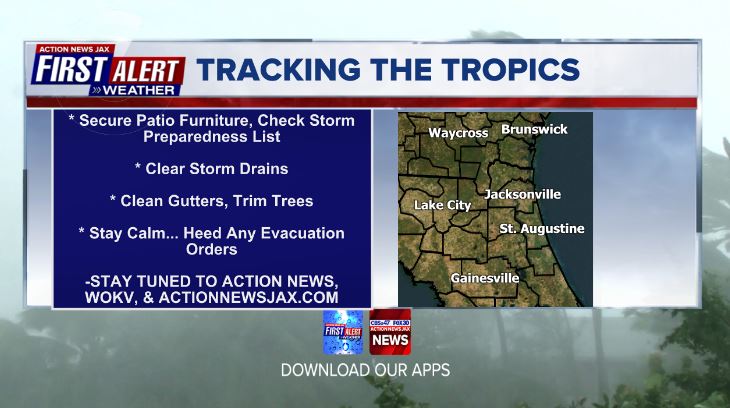
* So Wed. is the day to finalize checking your storm kits, preparing your yard & home for a storm, check & test (understand!) generators & top off gas tanks.
Atlantic Basin:
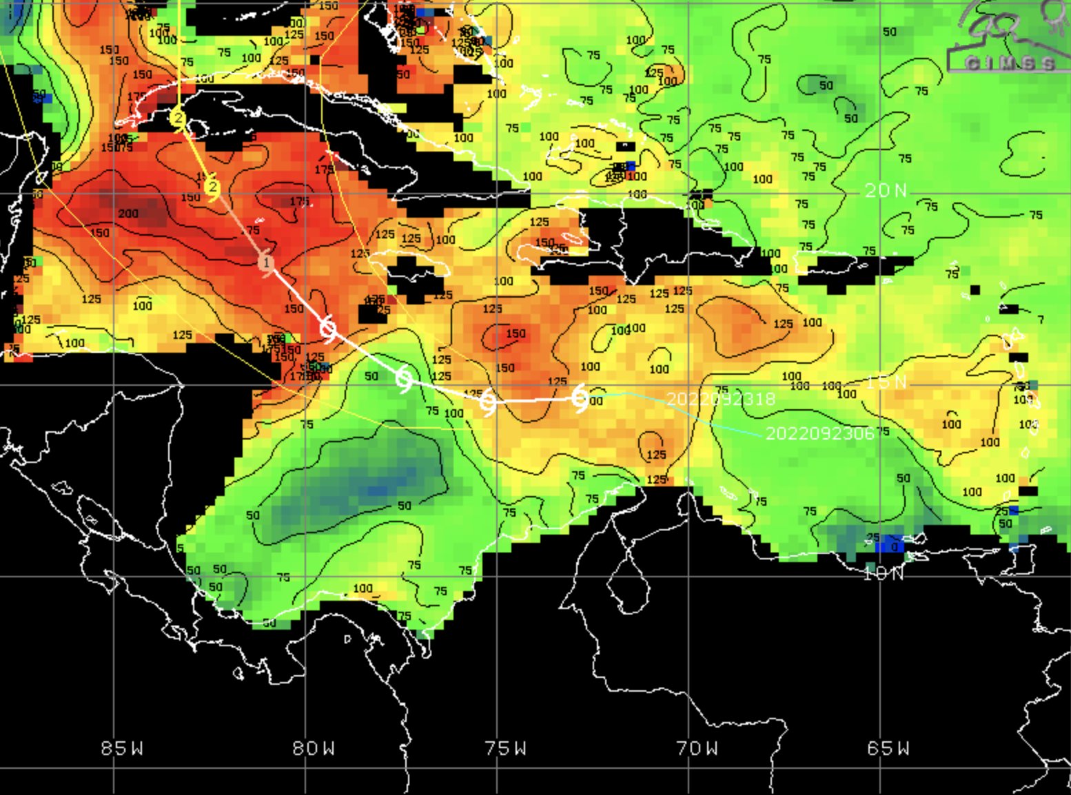
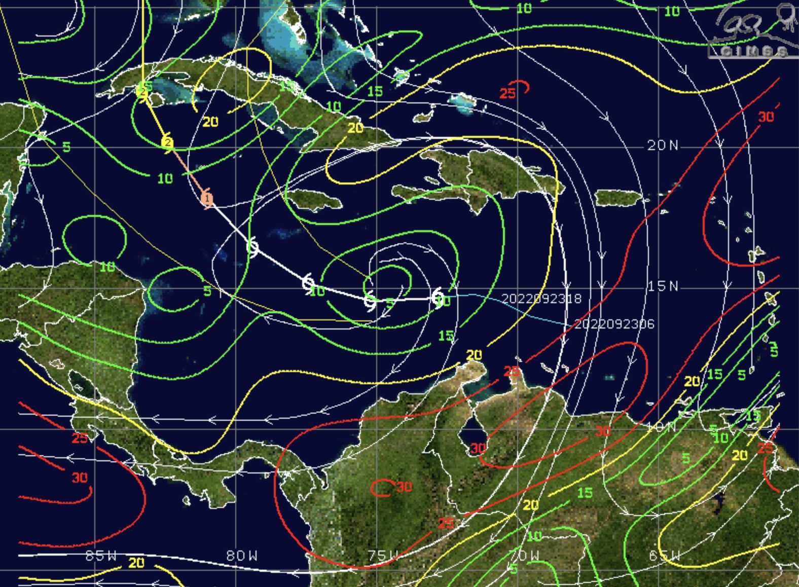
Tropical wave - ‘98-L’ that moved off of Africa last week is moving over the Southern Caribbean & Central Caribbean & was upgraded to tropical depression #9 Friday .... to tropical storm “Ian” Fri. evening... then to a hurricane early Mon. with a landfall over Western Cuba early Tue. as a Cat. 3 hurricane. This is a classic wave in that it formed from a complex of intense storms over Africa... encountered hostile conditions (shear & dry air) for days before finding more favorable conditions. Virtually all ingredients are in place for maintaining Ian’s intensity over the SE Gulf.
The global forecast models have finally come into much better agreement with the GFS & European models essentially right on top of one another though the European remains a little faster (generally by 6-8 hours). The GFS *has been* leading the charge so far on accuracy, especially as it relates to location & the longer westward movement the past several days, at the fork in the road - Cuba - the European has taken the accuracy lead. While the forecast model disparity has narrowed, there will still be some adjustments. The GFS has trended toward Tampa & now joins the European model pointing to the Fl. west coast a little south of Tampa. Confidence is high that the west coast of Florida will be hit by a strong hurricane Wed.-Thu. A more angled approach to the coast from the southwest means a landfall a little earlier. Friction from nearby land & increasing shear & dry air will bring Ian down from its peak intensity while moving inland once near/south of Tampa, but Ian will still be a powerful & large hurricane near the Florida west coast with a widening wind field while moving across Fl. into Thu. night while “sniffing” out the ocean again to the east. There did appear to be an eyewall replacement cycle occurring overnight Tue. If the cycle is completed in short order, Ian will have an opportunity to intensify some more more before landfall & before shear & dry air can start to eat away at the hurricane.
One should be careful about determining the threat to life & property based on the category of the storm & whether or not Ian is weakening. Dangerous impacts are imminent for a good part of Fl. It’s possible that the storm surge will be a category or so higher than what one might expect - than the actual category of the storm - for parts of the Fl. west coast... & even other parts of Florida.
Both the GFS & European models are initializing well which is a positive... the GFS was better on the more west & south track during the first 3 or so days of Ian’s lifetime, but the European is now doing better with the turn north then northeast toward Fl. So a major hit is likely on the Fl. west coast with significant impacts for much of Florida at one time or another - of varying degrees - for the rest of the week. Much of the Panhandle - especially the more west one goes - will be spared the worst. Storm surge into Tampa Bay is expected to be significant but *may* escape the worst since the eye is forecast to come ashore to the south of Tampa. The UKMET model has not been very good this season so far but, the model has joined most other global forecast models on the Fl. landfall & timing - on the west/SW coast of Fl. - but the model has been consistently too weak & - more than likely - is much too weak at landfall... then takes Ian to the east coast of Fl. before turning northward near or just east of Jacksonville. The UKMET has recently become more consistent on this outcome - & it’s something most models are indicating in form or another. Again - Ian will have major impacts for almost all of the Fl. Peninsula the next few days.
The drier mid & upper level air will increase as Ian gets closer to Fl. along with the increase in shear - this combination will hopefully - & should - drop Ian’s intensity from its peak over the Gulf & at landfall while moving inland. But do not let one’s guard down!
Steering currents to consider:
(1) model consistency & agreement is increasing. There are still question marks after landfall but even with that, it’s clear the west & SW coast of Fl. will be hit by a major hurricane that weakens while moving inland but still manages to produce very heavy rain & strong winds.
(2) there has been some “extra” ridging underneath - to the south of - once intense hurricane Fiona which is now long gone after having moved into Eastern Canada & the far NW Atlantic. This alone has likely helped the more westward track for the last few days. But a fairly broad trough over the Eastern U.S. + an upper level disturbance over the Western Gulf will help dictate the northeast move across the SE Gulf then the northeast track across Fl. As the upper trough over the Eastern U.S. departs & lifts out to the northeast, steering currents near Ian will weaken causing the hurricane to slow - especially near & after the Fl. landfall. A cold front dipping into Fl. has stalled between I-4 & Highway 16 (Central Fl.) & will focus the heaviest, most persistent rainfall along & north of the front... & may also create a path of sorts for Ian after landfall. I’ve noted some pressure falls near & along the front which is an alleyway Ian should be “attracted” to.

(3) a tropical storm/typhoon has formed over the W. Pacific & will move due west to Asia. Perhaps of more importance is a tropical cyclone a few days ago that turned rather sharply to the northeast & moved near & east of Japan & has since become a post-tropical low. A new tropical cyclone taking shape east of Japan will follow a similar path turning sharply northeast to the east of Japan. A teleconnection implies the sharper turn north/northeast for Ian. (W. Pacific track map at the bottom). The trough off the east coast of China essentially mirrors the trough near/off the east coast of the U.S. with strong low pressure to the east (Fiona over the Atlantic) followed by another trough to the east.
Movement summary:
Ian will at least stay far away from recently hard hit Puerto Rico & Dominican Republic. The time table - *for right now* is a hit on Florida’s west/southwest coast later Wed. then moving northeast to near Orlando by early Thu.... to east of Daytona Beach by Thu. night... to east of Jacksonville Fri. morning then another landfall near Savannah later Fri. It doesn’t look Ian will be able to significantly strengthen over the for Western Atlantic Fri. but may manage to remain steady state with the help of the warm but relatively shallow shelf water.


NHC interactive inundation forecast * here *


Spaghetti plots includes ensembles of the models. Definite shift east recently:


If Ian’s forecast track continues to trend west, the rainfall forecast should decrease - at least some:


Key West radar imagery:

Tampa radar imagery:

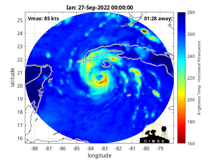
Integrated Microwave Imager, CIMSS:

Deep oceanic heat content is impressive across the Caribbean - lots of warm water well below the surface of the ocean:
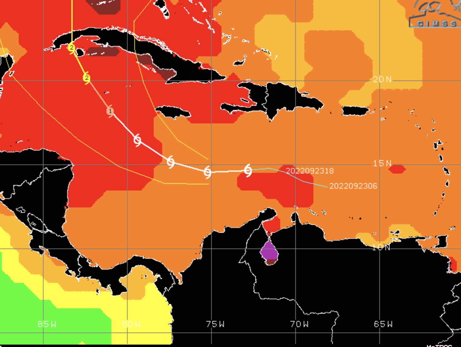
Strong shear over the far Eastern Caribbean weakens a great deal more to the north & west:
Radar imagery from S. Fl. Water Management District:

The upper level forecast for Wed. shows the trough of low pressure moving into the Northeast U.S. helping to tug Ian northward. The trough will lift out to the east by Fri. leaving behind weaker steering currents causing Ian to slow its forward speed:


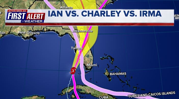
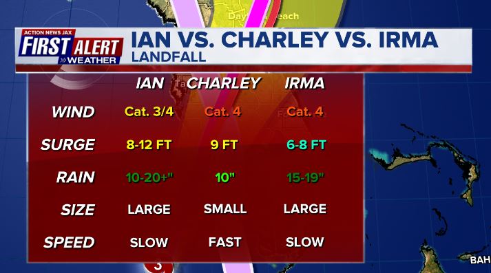
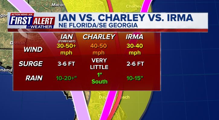
Comparison of tracks & impacts (at landfall & over/near Jacksonville) between Cat. 4 Charley in 2004, Cat. 4 Irma in 2017 & the forecast for Ian:
Elsewhere....
The last NHC advisories on Fiona, Hermine & Gaston have been issued.
A tropical wave is moving from the Eastern to Central Atlantic. Some development is possible as the wave turns more north staying far out to sea.... another wave is coming off the coast of Africa at a lower latitude & might have some long term potential.


Water vapor loop shows plenty of mid & upper level moisture (white & green areas) across a good part of the Atlantic Basin:


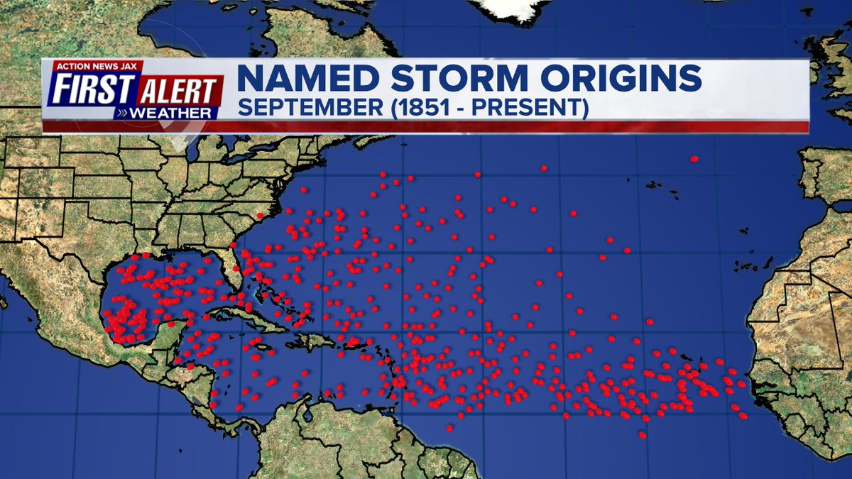
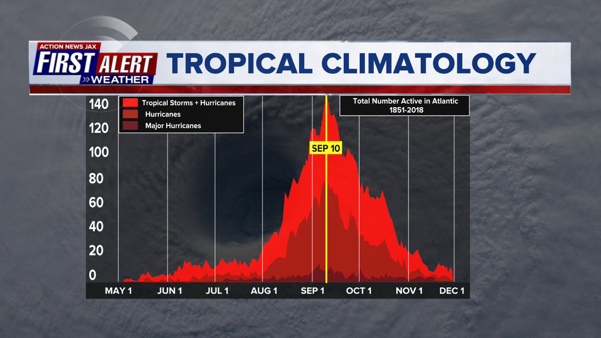
September origins:
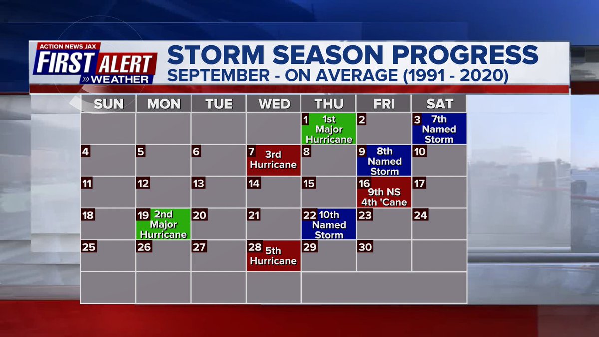
Averages below based on climatology for the Atlantic Basin through September. This season so far is well below avg.:
Wind shear:


Saharan dust spreads west each year from Africa by the prevailing winds (from east to west over the Atlantic). Dry air - yellow/orange/red/pink. Widespread dust is indicative of dry air that can impede the development of tropical cyclones. However, sometimes “wanna’ be” waves will just wait until they get to the other side of - or away from - the plume then try to develop if other conditions are favorable. In my personal opinion, way too much is made about the presence of Saharan dust & how it relates to tropical cyclones. In any case, we’ve had several large dust plumes spread west to the Caribbean & Gulf with the peak of Saharan dust typically in June & July.

2022 names..... “Julia” is the next name on the Atlantic list (names are picked at random by the World Meteorological Organization... repeat every 6 years). Historic storms are retired [Florence & Michael in ’18... Dorian in ’19 & Laura, Eta & Iota in ‘20 & Ida in ‘21]). In fact, this year’s list of names is rather infamous with “Charley”, “Frances”, “Jeanne” & “Ivan” retired from the ‘04 list (all hit Fl.) & “Matthew” was retired in 2016. The WMO decided - beginning last year - that the Greek alphabet will be no longer used & instead there will be a supplemental list of names if the first list is exhausted (has only happened three times - 2005, 2020 & 2021). The naming of tropical cyclones began on a consistent basis in 1953. More on the history of naming tropical cyclones * here *.

East Atlantic:


Mid & upper level wind shear (enemy of tropical cyclones) analysis (CIMMS). The red lines indicate strong shear:

Water vapor imagery (dark blue indicates dry air):

Deep oceanic heat content over the Gulf, Caribbean & deep tropical Atlantic:

Sea surface temp. anomalies:


SE U.S. surface map:
Surface analysis centered on the tropical Atlantic:

Surface analysis of the Gulf:

Caribbean:

GFS wave forecast at 48 & 72 hours (2 & 3 days):


Atlantic Basin wave period forecast for 24, 48 & 72 hours respectively:


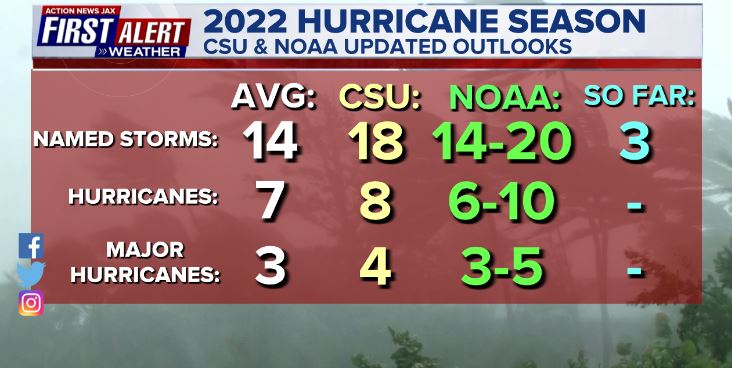
Updated Atlantic seasonal forecast from early Aug. - NOAA & CSU:
The East Pacific:


West Pacific:

Global tropical activity:


Typhoon “Noru” rolled across the Northern Philippines & is now headed to a Vietnam landfall:

“Kulap” will stay well east of Japan:

Cox Media Group


