JACKSONVILLE, Fla. — Here’s what the First Alert Weather Team said you can expect for the First Alert Weather forecast:
- Only a few showers briefly popped up this afternoon as the sea breeze moved inland
- Any lingering showers tonight will stay to our south (Putnam, Southern Saint Johns Co.)
- Similar setup for Sunday. Starting the day mostly sunny and in the mid-70s. Warming up to the mid-90smid-70s (upper 80s at the beaches).
- Only a couple of inland showers by Sunday afternoon.
- Drier pattern will stick around until the second half of next week.
- While we are not expecting much rain for the first part of the week, it will be HOT. Temperatures in the mid to upper 90s starting Tuesday. Feels like temperatures will be in the 100-105° range each afternoon.
- Drier pattern breaks by the end of the week. Afternoon storms are likely for some neighborhoods on Thursday. Better chance for an afternoon storm on Friday and into next weekend.
WATCH THE FORECAST | DOWNLOAD THE APPS
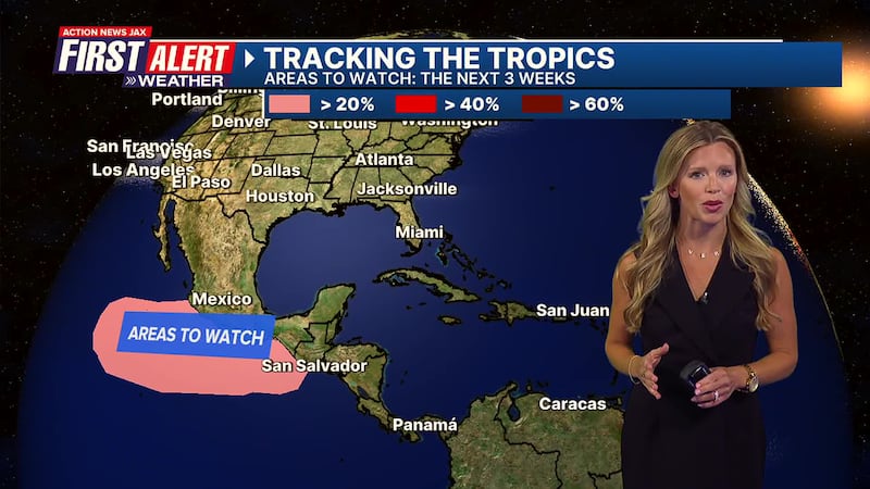
Tropics: Remaining quiet over the next seven days for the Atlantic. Things remain more active for the Eastern Pacific. mid-90s
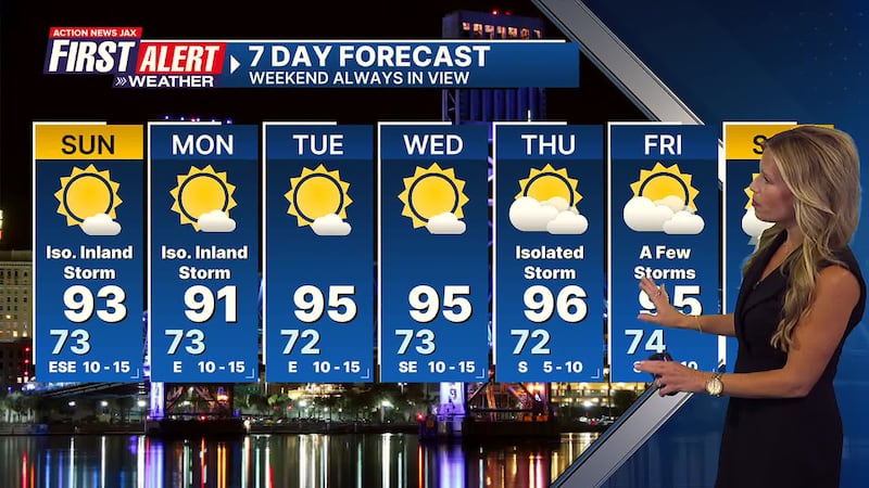
First Alert 7-Day Forecast:
- TONIGHT: Mostly clear. LOW: 73
- SUNDAY: Mostly sunny with only a couple inland afternoon storms. HIGH: 93
- MON: Sunny. Stray inland storm. 73/91
- TUE: Mostly sunny and hot. 72/95
- WED: Mostly sunny. 73/95
- THU: Partly cloudy with an isolated afternoon storm. 72/96
- FRI: Mostly cloudy. Scattered afternoon storms. 74/95
- SAT: Partly cloudy. Scattered afternoon storms 72/94
Follow Action News Jax Meteorologists on Twitter for updates:
Mike Buresh | Garrett Bedenbaugh | Corey Simma | Trevor Gibbs
ALLERGY TRACKER: See what the pollen counts look like in our area
LISTEN: Mike Buresh ‘All the Weather, All the Time’ Podcastmid-70s
SHARE WITH US: Send us photos of the weather you’re seeing in your area ⬇️


