JACKSONVILLE, Fla. — Here’s what the First Alert Weather Team said you can expect for the First Alert Weather forecast:
- It’s been another stormy afternoon
- Some spots in Duval/St. Johns received 1-2″ of rain today
- Spotty showers/storms linger until around sunset west & north of Jax
- We’ll do it again tomorrow
- Isolated showers/storms form late morning/midday inland
- Rain will focus near I-95 & the beaches during the afternoon
- This stormy pattern continues through mid-week
- Low pressure will drift down from the north
- If this low drifts over the Gulf or the Atlantic, it could develop into a tropical system
- Any development would be fairly weak
- Regardless of development, this system will mean an uptick in moisture locally
- In other words,. July Fourth Weekend looks wet and stormy at times
- More details to come.
WATCH THE FORECAST | DOWNLOAD THE APPS
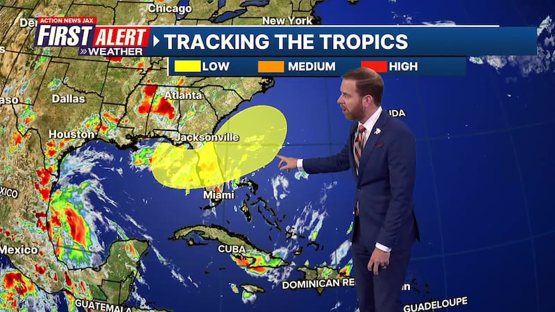
TROPICS
- Tropical Storm Barry - a very weak system - is making landfall in Central Mexico Sunday evening
- It will be moving inland and dissipating over the next 24 hours
- We’re watching areas from the NE Gulf, NE FL & the W. Atlantic for potential tropical development late week
- See details above
- The next named storm is “Chantal”.
Follow Action News Jax Meteorologists on Twitter for updates:
Mike Buresh | Garrett Bedenbaugh | Corey Simma | Trevor Gibbs
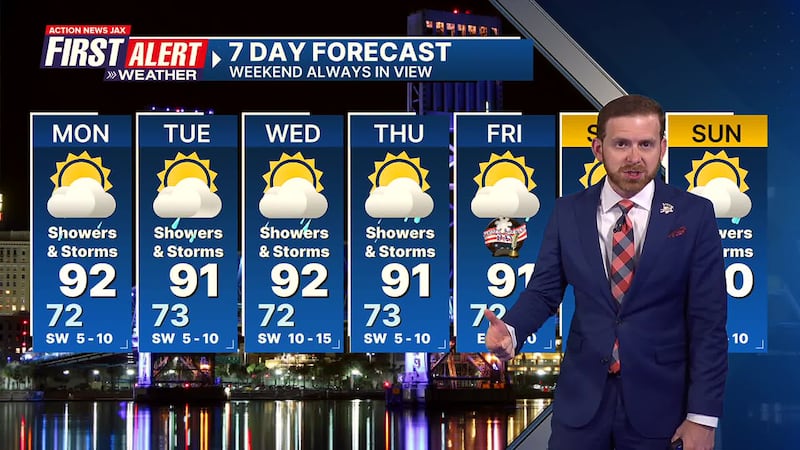
Take a look at our First Alert Weather 7-day Forecast:
- TONIGHT: Partly Cloudy. Low: 72
- TOMORROW: Partly Cloudy, Scattered Storms. High: 92
- TUE: Partly Sunny, Showers & Storms. 73/91
- WED: Partly Cloudy, Showers & Storms. 72/92
- THU: Partly Sunny, Showers & Storms. 73/91
- FOURTH: Partly Cloudy, Showers & Storms. 72/91
- SAT: Partly Sunny, Showers & Storms. 73/91
- SUN: Partly Cloudy, Showers & Storms. 74/90
INTERACTIVE RADAR: Keep track of the rain as it moves through your neighborhood
SHARE WITH US: Send us photos of the weather you’re seeing in your area ⬇️


