The world is watching & mourning as Texas reels from catastrophic flooding over the July 4th weekend. As of Tue., July 8th, the death toll is 109 & will undoubtedly go higher as dozens are missing. To put this in some perspective, there have been 765 flooding deaths in the U.S. since 1980. So the Texas death toll from a single flash flood event is a staggering 14%(+) of all the deaths attributed to flooding in the United States since 1980.
There is a lot to dissect about how & why this tragedy formed & unfolded & why so many lives were lost. Some very important points to begin with:
the Texas Hill country is a known to be prone to flash flooding & has a history of such
there were some cloud seeding operations more than 24 hours prior - by Rainmaker Technology. But cloud seeding only seeds existing clouds & studies indicate the peak estimated increase in rainfall is only near 20 percent IF successful. This was a *natural* disaster.
this was no one’s “fault” - politically or otherwise
the flash flood was *not* manufactured by, created by or manipulated in any way by humans or human technology.
The National Weather Service offices in Texas - San Antonio & San Angelo specifically - did a good job issuing watches, warnings & advisories with adequate staff available & working during the flash flooding.
Camp Mystic has grabbed many of the headlines as 20+ children, counselors & the owner lost their lives along the violently rising Guadalupe River. The river rose an astonishing 26 feet in less than 5 hours!
Some folks (meteorologists & not) have blamed former tropical storm “Barry” for the Texas deluge. So I looked back at the weather charts. What was a very weak Barry came ashore June 30th on the east central coast of Mexico. There is no recognizable spin (low pressure) at the surface shortly after landfall nor is there any upper level spin (vorticity) visible from the remnants of what would have been Barry. There was a strong push of tropical moisture northward from Mexico but that was amidst an already nearly saturated air mass that was engulfing much of Texas due to broad southerly flow out of Mexico & off the Gulf. So personally I don’t believe Barry was the true cause & the death toll should not be attributed to Barry. But given the scope of the disaster, it’s just semantics & the National Hurricane Center will most likely make the final call.
So it appears it was small scale weather features (mesoscale) that came together at the wrong time in the wrong place to cause the disaster. During the middle of the night July 3/4, a complex of heavy thunderstorms developed over Central Texas eventually forming its own atmosphere, of sorts - a mesoscale convective system (MCS). The system managed to develop an upper level disturbance with a cyclonic (low pressure/counterclockwise) circulation. This helped to “lift” the warm, tropical air mass even more & sustained slow moving thunderstorms over the same area for hours with rainfall rates of 3-5 inches per hour! Also included in the recipe:
early morning - well before sunrise, so it was dark.
long holiday weekend so campgrounds were full
hilly terrain with topographical input helping to cause very fast currents
Radar imagery from July 3-4 centered on Texas:
TEXAS FLOODS-Here’s a radar loop from the main event. From Thursday afternoon, July 3rd, through Sunday evening, July 6th.
A leftover “plume” of tropical moisture from the remnants of Tropical Storm Barry surged north into the state, in combination with elevated moisture from… pic.twitter.com/jAXlTJo4jM
Death toll rises after flash floods in Texas Hill Country HUNT, TEXAS - JULY 6: A search and recovery worker shines his flashlight through through murky waters near Camp Mystic, looking for remains of victims on July 6, 2025 in Hunt, Texas. Heavy rainfall caused flooding along the Guadalupe River in central Texas with multiple fatalities reported. (Photo by Jim Vondruska/Getty Images) (Jim Vondruska/Getty Images)
Death toll rises after flash floods in Texas Hill Country HUNT, TEXAS - JULY 6: Search and recovery leave the area around Camp Mystic in military transport vehicles on July 6, 2025 in Hunt, Texas. Heavy rainfall caused flooding along the Guadalupe River in central Texas with multiple fatalities reported. (Photo by Jim Vondruska/Getty Images) (Jim Vondruska/Getty Images)
Death toll rises after flash floods in Texas Hill Country HUNT, TEXAS - JULY 6: A Blackhawk Helicopter flies over Camp Mystic on July 6, 2025 in Hunt, Texas. Heavy rainfall caused flooding along the Guadalupe River in central Texas with multiple fatalities reported. (Photo by Jim Vondruska/Getty Images) (Jim Vondruska/Getty Images)
Death toll rises after flash floods in Texas Hill Country HUNT, TEXAS - JULY 6: A search and recovery team drives an armored vehicle used to transport remains of victims near Camp Mystic on July 6, 2025 in Hunt, Texas. Heavy rainfall caused flooding along the Guadalupe River in central Texas with multiple fatalities reported. (Photo by Jim Vondruska/Getty Images) (Jim Vondruska/Getty Images)
Death toll rises after flash floods in Texas Hill Country HUNT, TEXAS - JULY 6: A Chinook helicopter takes off near Camp Mystic after picking up troops that aided in search and recovery efforts on July 6, 2025 in Hunt, Texas. Heavy rainfall caused flooding along the Guadalupe River in central Texas with multiple fatalities reported. (Photo by Jim Vondruska/Getty Images) (Jim Vondruska/Getty Images)
Death toll rises after flash floods in Texas Hill Country HUNT, TEXAS - JULY 6: An SUV is covered in debris near Camp Mystic on July 6, 2025 in Hunt, Texas. Heavy rainfall caused flooding along the Guadalupe River in central Texas with multiple fatalities reported. (Photo by Jim Vondruska/Getty Images) (Jim Vondruska/Getty Images)
Death toll rises after flash floods in Texas Hill Country HUNT, TEXAS - JULY 6: Search and recovery workers make their way to debris fields along the Guadalupe River looking for any survivors or remains of people swept up in the flash flooding near Camp Mystic on July 6, 2025 in Hunt, Texas. Heavy rainfall caused flooding along the Guadalupe River in central Texas with multiple fatalities reported. (Photo by Jim Vondruska/Getty Images) (Jim Vondruska/Getty Images)
Death toll rises after flash floods in Texas Hill Country HUNT, TEXAS - JULY 6: Search and recovery workers dig through debris looking for any survivors or remains of people swept up in the flash flooding near Camp Mystic on July 6, 2025 in Hunt, Texas. Heavy rainfall caused flooding along the Guadalupe River in central Texas with multiple fatalities reported. (Photo by Jim Vondruska/Getty Images) (Jim Vondruska/Getty Images)
Death toll rises after flash floods in Texas Hill Country HUNT, TEXAS - JULY 6: Search and recovery workers dig through debris looking for any survivors or remains of people swept up in the flash flooding at Camp Mystic on July 6, 2025 in Hunt, Texas. Heavy rainfall caused flooding along the Guadalupe River in central Texas with multiple fatalities reported. (Photo by Jim Vondruska/Getty Images) (Jim Vondruska/Getty Images)
Death toll rises after flash floods in Texas Hill Country HUNT, TEXAS - JULY 6: Search and recovery workers dig through debris looking for any survivors or remains of people swept up in the flash flooding at Camp Mystic on July 6, 2025 in Hunt, Texas. Heavy rainfall caused flooding along the Guadalupe River in central Texas with multiple fatalities reported. (Photo by Jim Vondruska/Getty Images) (Jim Vondruska/Getty Images)
Death toll rises after flash floods in Texas Hill Country HUNT, TEXAS - JULY 6: Search and recovery workers dig through debris looking for any survivors or remains of people swept up in the flash flooding at Camp Mystic on July 6, 2025 in Hunt, Texas. Heavy rainfall caused flooding along the Guadalupe River in central Texas with multiple fatalities reported. (Photo by Jim Vondruska/Getty Images) (Jim Vondruska/Getty Images)
Death toll rises after flash floods in Texas Hill Country HUNT, TEXAS - JULY 6: Search and recovery workers dig through debris looking for any survivors or remains of people swept up in the flash flooding near Camp Mystic on July 6, 2025 in Hunt, Texas. Heavy rainfall caused flooding along the Guadalupe River in central Texas with multiple fatalities reported. (Photo by Jim Vondruska/Getty Images) (Jim Vondruska/Getty Images)
Death toll rises after flash floods in Texas Hill Country HUNT, TEXAS - JULY 6: A Texas Department of Public Safety vehicle sits on the road above where search and recovery workers are digging through debris looking for any survivors or remains of people swept up in the flash flooding near Camp Mystic on July 6, 2025 in Hunt, Texas. Heavy rainfall caused flooding along the Guadalupe River in central Texas with multiple fatalities reported. (Photo by Jim Vondruska/Getty Images) (Jim Vondruska/Getty Images)
Death toll rises after flash floods in Texas Hill Country HUNT, TEXAS - JULY 6: Search and recovery workers dig through debris looking for any survivors or remains of people swept up in the flash flooding at Camp Mystic on July 6, 2025 in Hunt, Texas. Heavy rainfall caused flooding along the Guadalupe River in central Texas with multiple fatalities reported. (Photo by Jim Vondruska/Getty Images) (Jim Vondruska/Getty Images)
Death toll rises after flash floods in Texas Hill Country HUNT, TEXAS - JULY 6: Search and recovery workers dig through debris looking for any survivors or remains of people swept up in the flash flooding at Camp Mystic on July 6, 2025 in Hunt, Texas. Heavy rainfall caused flooding along the Guadalupe River in central Texas with multiple fatalities reported. (Photo by Jim Vondruska/Getty Images) (Jim Vondruska/Getty Images)
Death toll rises after flash floods in Texas Hill Country HUNT, TEXAS - JULY 6: Search and recovery workers dig through debris looking for any survivors or remains of people swept up in the flash flooding at Camp Mystic on July 6, 2025 in Hunt, Texas. Heavy rainfall caused flooding along the Guadalupe River in central Texas with multiple fatalities reported. (Photo by Jim Vondruska/Getty Images) (Jim Vondruska/Getty Images)
Death toll rises after flash floods in Texas Hill Country HUNT, TEXAS - JULY 6: Search and recovery workers dig through debris looking for any survivors or remains of people swept up in the flash flooding near Camp Mystic on July 6, 2025 in Hunt, Texas. Heavy rainfall caused flooding along the Guadalupe River in central Texas with multiple fatalities reported. (Photo by Jim Vondruska/Getty Images) (Jim Vondruska/Getty Images)
Death toll rises after flash floods in Texas Hill Country HUNT, TEXAS - JULY 6: Children's clothes hang on the branch of a tree on the bank of the Guadalupe River near Camp Mystic on July 6, 2025 in Hunt, Texas. Heavy rainfall caused flooding along the Guadalupe River in central Texas with multiple fatalities reported. (Photo by Jim Vondruska/Getty Images) (Jim Vondruska/Getty Images)
“If Mother Nature cannot be commanded, She should be obeyed”.
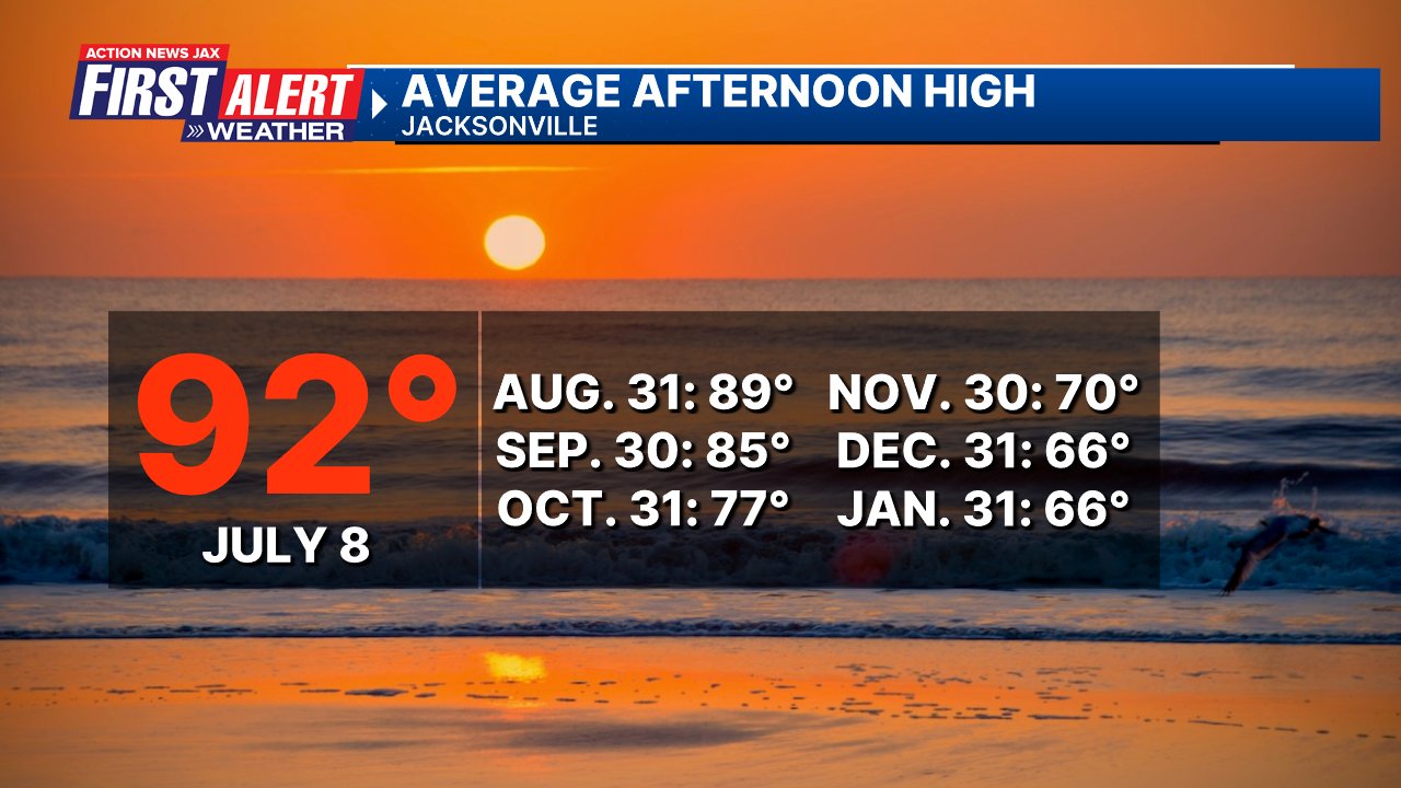
Moving on to local weather ... Jacksonville is now in the true “Dog Days” of summer. Our avg. high temp. at 92 degrees is the hottest of the year & continues to be the avg. into early Aug. Our avg. high temp. does not fall below 90 degrees until near the end of Aug. Stay cool & drink lots of water!
I came across this very interesting map - from ‘PAwx’ on ‘X’ of the strongest tornadoes ever recorded in each county in the U.S.. For instance - the strongest in Duval Co. is an EF-2... in St. Johns Co. - an EF-3:
Officially out! Updated Strongest Tornado in Each county! 1700-Now Purple= F/EF5 Red= F/EF4 Orange= F/EF3 Yellow= F/EF2 Dark Blue= F/EF1 Light Blue= F/EF0 Black= No tornadoes or F/EFU pic.twitter.com/BzTm6TTWEn