
JACKSONVILLE, Fla. — To become a part of the First Alert Neighborhood weather station network powered by Tempest - scan below &/or click * here *:

Updated every day throughout the hurricane season - “Talking the Tropics With Mike”. There are indications (& no surprise given the time of year & typical progress of the hurricane season) that the first few weeks of August could become quite active across the Atlantic Basin.

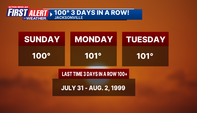
Our hot summer continues to sizzle with 100+ degree temps. at least 3 days in a row as of July 29th. Some milestones when it comes to 100-degree days in Jacksonville:
- the last time there have been at more than 3 100-degree days in the same year is 2010 (4)
- 3 straight 100-degree days has not happened this century. The last time was in 1999 from July 31-August 2nd. But still well below the record for Jacksonville of 7 straight 100+ degree days in 1981 from July 11th - 17th.
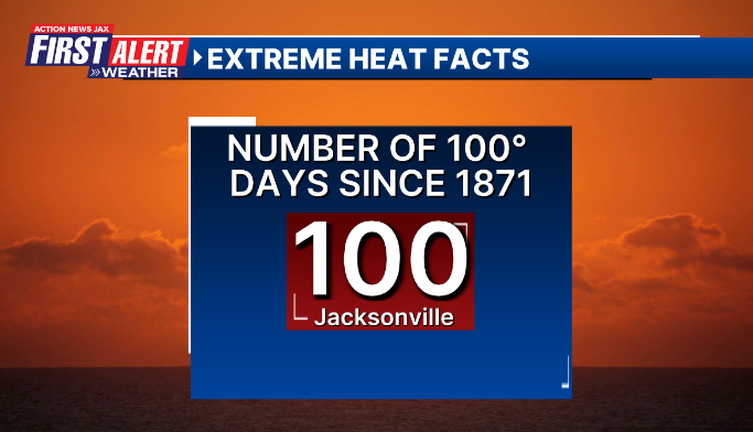
- Tue., July 29th marked the 100th 100-degree day in Jacksonville’s weather history which goes back to 1871.
- July, 2025 will end up in the top 3 or 4 of the hottest July’s on record.
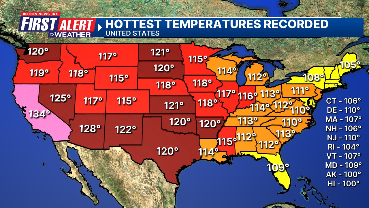
I found this info. - courtesy NOAA - interesting - the hottest temps. for the U.S. Each state has managed to hit 100 degrees at one time or another. What many don’t realize is that most states north of Florida have had hotter temps. thanks to Florida’s location sandwiched between the Atlantic to the east & the Gulf to the west which equals frequent summer sea breezes. Summer afternoon “cooling” t’storms are also common. The all-time record high for Florida of 109 degrees F. was in Monticello in the Panhandle northeast of Tallahassee set on June 29th, 1931. The all-time high for Georgia was in Greenville on Aug. 20, 1983.
So we turn the calendars to August(!!). We’re half way through our “wet season”... & we lose nearly 50 minutes of daylight. Averages for JIA:

And some good news from NOAA & the U.S. Gov’t of Defense - the SSMIS satellite data *will* now remain accessible. This high resolution satellite data is very useful particularly during the hurricane season & especially for overnight observation in more remote areas.
🚨🚨 I've independently confirmed with @NOAA that they received a late-breaking notice from @DeptofDefense that SSMIS data will continue to flow for the remainder of the lifespan of the satellites. I will be updating my reporting shortly. Here is the official NOAA statement 👇 https://t.co/urD4sr2dIy pic.twitter.com/FK8682ls5q
— Michael Lowry (@MichaelRLowry) July 29, 2025


