:quality(70)/cloudfront-us-east-1.images.arcpublishing.com/cmg/4BY52YP3URHB3CBG6342FEUNGQ.jpg)
Jacksonville, FL — “Talking the Tropics With Mike” - updated everyday through Nov. 30th.
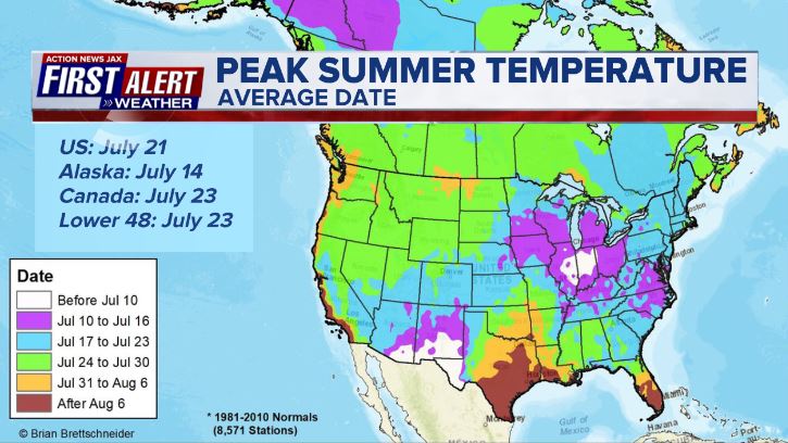
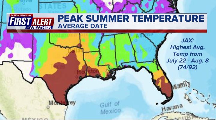
It’s the peak of midsummer heat for the U.S. including Jacksonville/NE Fl./SE Ga. The *average* hottest stretch of temps. for Jacksonville specifically is July 22 - Aug. 8 with a high of 92 & a low of 74 degrees F respectively.
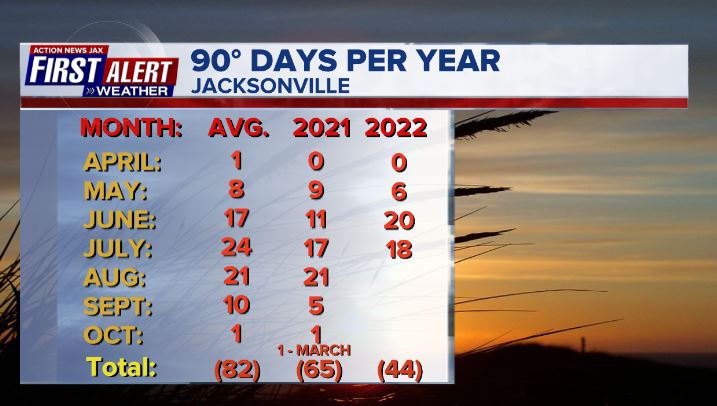
As of July 20th, Jacksonville has had 44 90-degree days. The average for the year is 82 days.
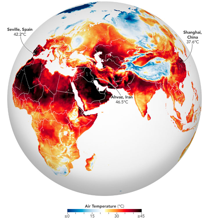
The week has been the hottest ever recorded for parts of Europe including 40 degrees C/104 degrees F in London.
So I found this on Twitter from @tornadoarchive - a tornado histogram of sorts - pretty cool. Pretty interesting to see how tornado climatology changes based on an ever-changing/evolving society.
Coming soon: US Tornadoes 1680-1880. By scrubbing through these years, one can see the evolution of tornado science, public attitude & knowledge, documentation, as well as the expansion of the U.S! @sigtor2019 @NWSPC #wxtwitter Well done, Tornado Archive content team! pic.twitter.com/45uJFybcEe
— Tornado Archive (@torarchive) July 19, 2022
This week - July 16-20 - has been dominated by numerous midday through afternoon into the evening storms resulting in a myriad of beautiful scenery. Some pics & vids below (see @mikefirstalert on Instagram, Twitter & Facebook:
#firstalertwx Patricia Sebastian in St. Augustine Thu. afternoon, 07/14 @ActionNewsJax @WOKVNews pic.twitter.com/Ec2qGhpSCq
— Mike Buresh (@MikeFirstAlert) July 15, 2022
#firstalertwx https://t.co/7yDuOLVpzI
— Mike Buresh (@MikeFirstAlert) July 17, 2022
sharp shelf cloud north of St. Augustine as strong storms move eastward through St. Johns Co. @actionnewsjax @wokvnews #FirstAlertWx pic.twitter.com/eYgu9G7EE9
— Mike Buresh (@MikeFirstAlert) July 19, 2022
#firstalertwx https://t.co/sACOd9RBbW
— Mike Buresh (@MikeFirstAlert) July 20, 2022
#firstalertwx https://t.co/5ZTJ2DwzPp
— Mike Buresh (@MikeFirstAlert) July 20, 2022
#firstalertwx https://t.co/TumXn47rVx
— Mike Buresh (@MikeFirstAlert) July 20, 2022
#firstalertwx Jax Beach First Alert Skycam Network - Tue., 07/19 @ActionNewsJax @WOKVNews pic.twitter.com/YNolNxHiRU
— Mike Buresh (@MikeFirstAlert) July 20, 2022
#firstalertwx Fernandina Beach time lapse - storm/sunset combo @ActionNewsJax @WOKVNews pic.twitter.com/wVsinehjbG
— Mike Buresh (@MikeFirstAlert) July 20, 2022
#firstalertwx by Tim Robinson, Jacksonville Beach (Tue., 07/19) @ActionNewsJax @WOKVNews pic.twitter.com/rh9eeT5sTk
— Mike Buresh (@MikeFirstAlert) July 20, 2022
#firstalertwx https://t.co/BmQ8yVnAJF
— Mike Buresh (@MikeFirstAlert) July 20, 2022
#firstalertwx https://t.co/lSBTUYaxUo
— Mike Buresh (@MikeFirstAlert) July 21, 2022
©2022 Cox Media Group
:quality(70)/d1hfln2sfez66z.cloudfront.net/04-24-2024/t_d73855398dca4bf5a6e1eca4fedb0fdd_name_file_960x540_1200_v3_1_.jpg)
:quality(70)/cloudfront-us-east-1.images.arcpublishing.com/cmg/LD6DBNVYAJFLJA3FWTZQ2LXOEE.jpg)
:quality(70)/cloudfront-us-east-1.images.arcpublishing.com/cmg/7CGTFGZFDVC5JDOBQ4SVBP3WBA.jpg)
:quality(70)/d1hfln2sfez66z.cloudfront.net/04-25-2024/t_6708df192ad447aabcf5b5aa3616cc76_name_file_960x540_1200_v3_1_.jpg)
:quality(70)/d1hfln2sfez66z.cloudfront.net/04-26-2024/t_e1c14cbb11b5404e9130e1284c8af083_name_file_960x540_1200_v3_1_.jpg)