JACKSONVILLE, Fla. — The First Alert Weather team is tracking storms that could bring heavy rain, lightning, and bursts of winds to the area this afternoon.
Notes from the First Alert Weather Team:
- Saturday morning is dry and mostly clear with temperatures in the upper 60s to upper 70s.
- Saturday evening will be seasonally hot with highs in the low 90s.
- Showers and thunderstorms will arrive by early Saturday afternoon and fade by early evening, with coverage greatest between Highway 301 and the beaches.
- Storms may be locally intense with brief heavy rain, frequent lightning, and gusty winds.
- Sunday will be a repeat of Saturday.
- Wet and unsettled weather remains into next week.
TROPICS:
- An area of low pressure will enter the far southwestern Gulf on Saturday and has a medium chance of becoming a short-lived tropical depression or storm.
- The next name is Barry. Regardless of development, this stays far to our south with no impact to the United States.
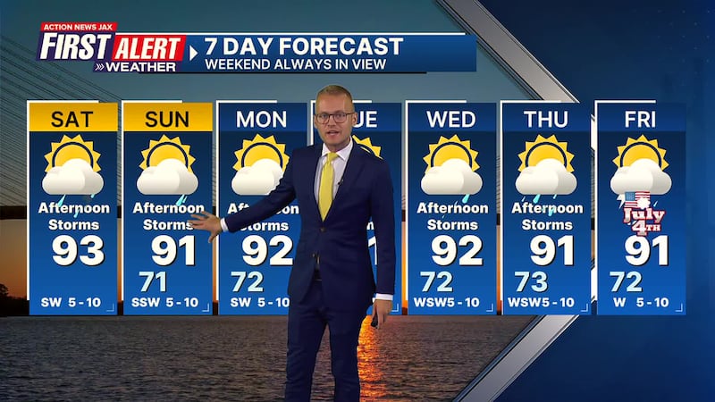
Take a look at our First Alert Weather 7-day forecast:
SATURDAY: Partly cloudy with scattered afternoon showers/storms. HIGH: 93
SATURDAY NIGHT: A shower/storm early, then partly cloudy. LOW: 71
SUNDAY: Partly cloudy with scattered afternoon showers/storms. 71/91
MONDAY: Partly cloudy with scattered afternoon showers/storms. 72/92
TUESDAY: Partly cloudy with a few afternoon showers/storms. 73/91
WEDNESDAY: Partly cloudy with scattered afternoon showers/storms. 72/92
THURSDAY: Partly cloudy with scattered afternoon showers/storms. 73/91
FRIDAY/JULY 4: Partly cloudy with a few afternoon showers/storms. 72/91
WATCH THE FORECAST | DOWNLOAD THE APPS
ALLERGY TRACKER: See what the pollen counts look like in our area
LISTEN: Mike Buresh ‘All the Weather, All the Time’ Podcast
INTERACTIVE RADAR: Keep track of the rain as it moves through your neighborhood
SHARE WITH US: Send us photos of the weather you’re seeing in your area ⬇️


