JACKSONVILLE, Fla. — The Action News Jax First Alert Weather Team is tracking temperatures in the 90s, afternoon storms in Florida, and Chantal’s landfall.
Notes from the First Alert Weather Team:
- Sunday will be hot with highs in the 90s across our entire area.
- The morning hours will be mainly dry with scattered afternoon thunderstorms moving southwest to northeast across north Florida Sunday afternoon. Less coverage of rain is expected for South Georgia.
- Storms will be capable of very heavy rain, frequent lightning, and gusty winds.
- Lower risk of rip currents at the beaches on Sunday, thanks to a predominantly offshore wind.
- Heat continues into the upcoming week with highs each day well into the 90s and a daily chance for some afternoon thunderstorms.
TROPICS:
- Tropical Storm Chantal made landfall near Litchfield Beach, South Carolina, Sunday morning as a 50 mph tropical storm (max winds briefly were 60 mph as the storm approached landfall).
- Chantal will weaken Sunday as it moves over land, returning our seas and surf to a normal state.
- Elsewhere, there are no areas of concern in the tropics. The next name is Dexter.
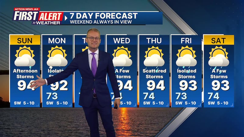
Take a look at the First Alert Weather 7-day forecast:
SUNDAY: Partly cloudy and hot with afternoon storms, especially in FL. HIGH: 94
SUNDAY NIGHT: Partly cloudy. LOW: 73
MONDAY: Partly cloudy with isolated afternoon storms. 73/92
TUESDAY: Partly cloudy and hot with isolated afternoon storms. 72/95
WEDNESDAY: Partly cloudy with a few afternoon storms. 74/94
THURSDAY: Partly cloudy with scattered afternoon storms. 74/94
FRIDAY: Partly cloudy with isolated storms. 73/93
SATURDAY: Partly cloudy with a few storms. 74/93
WATCH THE FORECAST | DOWNLOAD THE APPS
ALLERGY TRACKER: See what the pollen counts look like in our area
LISTEN: Mike Buresh ‘All the Weather, All the Time’ Podcast
INTERACTIVE RADAR: Keep track of the rain as it moves through your neighborhood
SHARE WITH US: Send us photos of the weather you’re seeing in your area ⬇️


