JACKSONVILLE, Fla. — Temperatures this morning are in the 70s under mostly clear skies.
- Today will feature another round of showers and thunderstorms in the afternoon and early evening.
- Storms will develop between 2 p.m. and 4 p.m.
- Coverage of storms will be greatest in areas similar to this weekend in between US-301 and the beaches where the sea breezes collide.
- Storms will be capable of very heavy rain, frequent lightning and strong gusty winds.
- Highs will rise into the upper 80s to low 90s before rain/clouds cool things off.
- This weather pattern continues this week with a daily chance for storms. Heavy rain could, at times, lead to minor flooding.
- The greatest rain totals this week will be well inland along I-75 to Highway 301 in NE Florida.
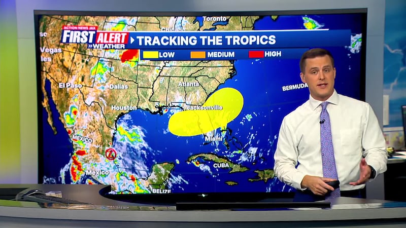
TROPICS:
- Barry made landfall Sunday night as a tropical depression along Mexico’s Gulf Coast.
- We’re watching areas from the NE Gulf, NE FL & the W. Atlantic for the potential for an area of low pressure to develop this upcoming weekend.
- Regardless of tropical formation, heavy rain will be increasing across the state of Florida this week.
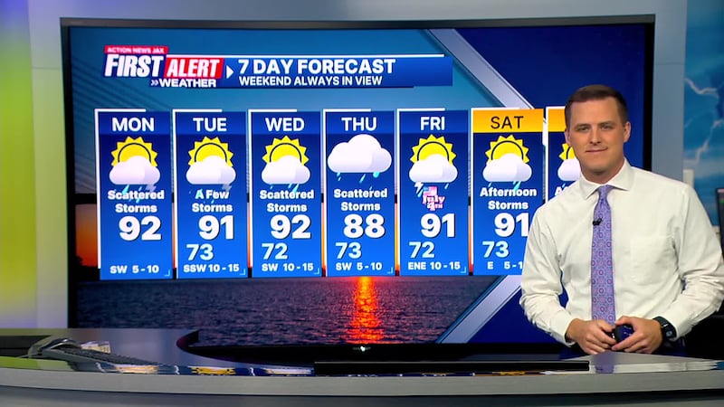
TODAY: Partly cloudy with scattered afternoon thunderstorms. HIGH: 92
TONIGHT: Shower/storm early then turning mostly clear. LOW: 73
TUESDAY: Partly cloudy with scattered afternoon storms. 73/91
WEDNESDAY: Partly cloudy with scattered afternoon storms. 72/92
THURSDAY: Partly cloudy with scattered afternoon storms. 73/88
INDEPENDANCE DAY: Partly cloudy with scattered afternoon storms. 72/91
SATURDAY: Partly cloudy with scattered afternoon storms. 73/91
SUNDAY: Partly sunny with scattered afternoon storms. 74/90
>>> STREAM ACTION NEWS JAX LIVE <<<
[DOWNLOAD: Free Action News Jax app for alerts as news breaks]
[SIGN UP: Action News Jax Daily Headlines Newsletter]
Click here to download the free Action News Jax news and weather apps, click here to download the Action News Jax Now app for your smart TV and click here to stream Action News Jax live.