JACKSONVILLE, Fla. — Notes from the First Alert Weather Team:
- It’s just the latest sunny & dry day across the area
- Temps will approach 90 degrees Saturday afternoon
- Sunday will be partly sunny & hot again
- Daytime highs approach records in the low 90s
- We’re tracking a few isolated showers/storms that will develop Sunday afternoon
- Best chance for rain will be inland & in SE GA
- Onshore winds surge down on Monday, bringing the best chance for rain for some in about 3 weeks
- A few showers will be near the coast Monday morning
- Then they’ll shift to I-95 midday & inland through the afternoon
- We turn dry mid-week & slightly cooler, but not for long
- Temps warm back to near 90 degrees by late week with showers chances returning
ALLERGY TRACKER: See what the pollen counts look like in our area
WATCH THE FORECAST | DOWNLOAD THE APPS
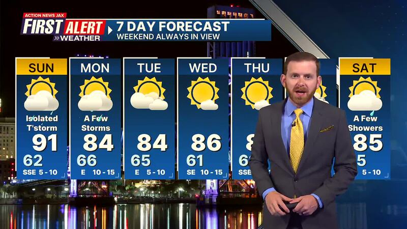
Here’s a look at your First Alert 7-Day Forecast:
- TONIGHT: Mostly Clear & Mild. Low: 62
- TOMORROW: Partly Sunny & Hot, Isolated Storms. High: 91 (Record: 94 - 1986)
- MON: Partly Cloudy & Breezy, A Few Showers/Storms. 66/84
- TUE: Partly to Mostly Sunny. 65/84
- WED: Mostly Sunny. 61/86
- THU: Mostly Sunny. 62/87
- FRI: Partly Cloudy, Isolated Shower. 65/89
- SAT: Partly Cloudy, A Few Showers. 65/85
[SIGN UP: Action News Jax Daily Headlines Newsletter]
Click here to download the free Action News Jax news and weather apps, click here to download the Action News Jax Now app for your smart TV and click here to stream Action News Jax live.


