JACKSONVILLE, Fla. — The First Alert Weather Team is tracking a few inland moving downpours Thursday evening and looking ahead to near-record heat.
Notes from the meteorologist:
- Downpours and storms will be west of Jacksonville for the evening commute
- Warm and muggy evening
- Tomorrow will be hot and humid with highs in the mid 90s inland and at or just above 90 at the coast.
- Isolated shower/storm in the afternoon on Friday.
- Triple-digit & near record heat is in the First Alert Forecast for Sun/Mon
- Feels like temps will soar between 105-115
- The days dry out with just isolated storms Saturday & no rain Sun/Mon
- Consider the heat for any outdoor plans over the weekend
INTERACTIVE RADAR: Keep track of the rain as it moves through your neighborhood
WATCH THE FORECAST | DOWNLOAD THE APPS
Tropics
- Low pressure in the Northeast Gulf is tracking westward & away from Florida
- This system will bring increased rain & storms to the Northern Gulf Coast
- No other areas of concern through the weekend.
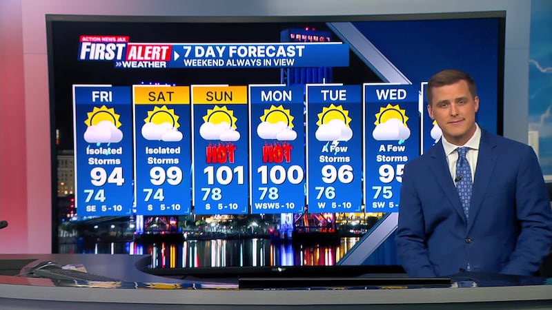
First Alert 7-Day Forecast
- TONIGHT: Partly cloudy. Low: 74
- TOMORROW: Partly sunny and hot. Isolated afternoon storm. High: 94 (Feels like: 105)
- SATURDAY: Partly to mostly sunny, Isolated afternoon storm. 74/99 (Record: 102 - 1874)
- SUNDAY: Partly to mostly sunny, Very hot. 78/101 (Record: 100 - 1872)
- MONDAY: Mostly sunny, Very hot. 78/100 (Record: 104 - 1872)
- TUESDAY: Partly sunny, A few storms. 76/96
- WEDNESDAY: Partly cloudy, A few storms. 75/95
- THURSDAY: Partly sunny. Isolated afternoon storm. 76/95
Follow Action News Jax Meteorologists on Twitter for updates:
Mike Buresh | Garrett Bedenbaugh | Corey Simma | Trevor Gibbs
SHARE WITH US: Send us photos of the weather you’re seeing in your area ⬇️


