JACKSONVILLE, Fla. — Tracking the potential for an isolated shower to roll off the Atlantic this morning in NE Florida.
- Breezy onshore winds today at 15-20 mph today.
- Gusts of 30 mph possible at the coast.
- A few showers will develop offshore and head inland this afternoon in NE Florida.
- Highs today in the lower to mid 80s well inland and upper 70s to near 80 degrees along the coast.
- Scattered showers will develop tomorrow as onshore winds continue.
- Large waves and a high rip current risk remain at local beaches into the weekend.
- This weekend looks wet at times with highs in the lower 80s.
- Especially rainy at the coast to about Highway 301 inland.
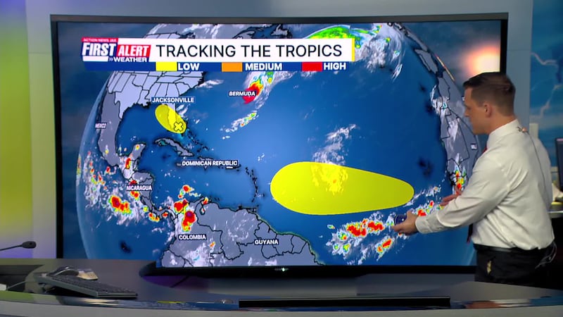
TROPICS:
- Imelda has moved east of Bermuda
- No other areas of concern.
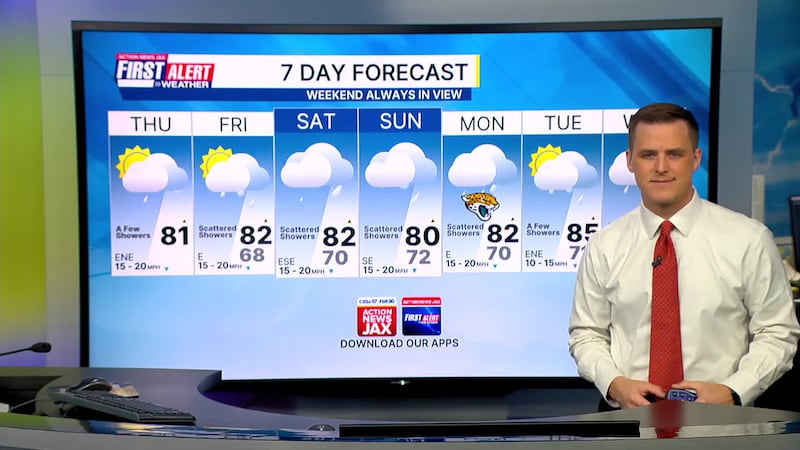
TODAY: Partly cloudy with a few showers. Breezy. HIGH: 81
TONIGHT: Partly cloudy and breezy. Isolated showers. LOW: 68
FRIDAY: Partly cloudy, a few showers. Breezy. 68/82
SATURDAY: Mostly cloudy, scattered showers. Breezy. 70/82
SUNDAY: Cloudy, scattered showers. Breezy. 69/80
MONDAY: Cloudy with scattered showers. 70/82
TUESDAY: Partly cloudy with a few showers. 71/85
WEDNESDAY: Partly cloudy with a few showers. 69/85
WATCH THE FORECAST | DOWNLOAD THE APPS
Follow Action News Jax Meteorologists on Twitter for updates:
Mike Buresh | Garrett Bedenbaugh | Corey Simma | Trevor Gibbs
ALLERGY TRACKER: See what the pollen counts look like in our area
LISTEN: Mike Buresh ‘All the Weather, All the Time’ Podcast
INTERACTIVE RADAR: Keep track of the rain as it moves through your neighborhood
SHARE WITH US: Send us photos of the weather you’re seeing in your area ⬇️


