JACKSONVILLE, Fla. — UPDATE 10 a.m.: As of 8 a.m., Tropical Depression 3 has become Tropical Storm Chantal, the third named storm of the 2025 season.
Our only local impacts will be a high risk of rip currents at all beaches and some gusty winds at the beaches through this afternoon.
END UPDATE
Original post:
The First Alert Weather Team is tracking a warm and humid Saturday with a few inland storms, gusty winds, and dangerous beach conditions.
Notes from the First Alert Weather Team:
- Saturday morning is mostly dry with temperatures in the 70s under partly cloudy skies.
- Saturday will be warm and humid with highs ranging from the middle 80s along the coast to the lower 90s inland.
- A few areas of rain are expected with some coastal showers Saturday morning, shifting to inland thunderstorms by the afternoon.
- Many locations will see abundant dry time this weekend.
- Gusty winds at the beaches and along the St. Johns River are likely, ranging from 15-25 mph.
- A high risk of rip currents is in place for the southeast Georgia beaches, with a high-end moderate risk for northeast Florida. Beach-goers are advised to stay out of the water.
- Temperatures rise into the middle 90s next week with some drier days.
TROPICS:
- Tropical Depression 3 is forecast to become Tropical Storm Chantal later Saturday.
- The system will drift north toward the South Carolina coast, moving away from our local area.
- The only local impacts associated with TD3/Chantal will be rip currents and gusty winds at the beaches on Saturday.
- No other areas of concern.
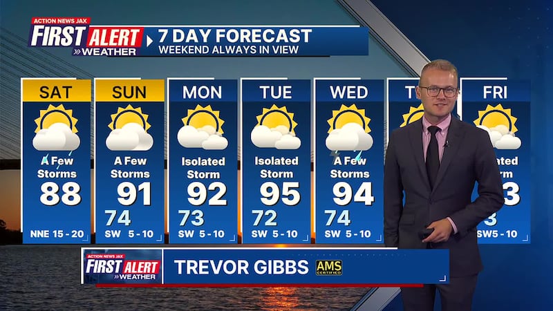
Take a look at our First Alert Weather 7-day forecast:
SATURDAY: Partly cloudy with a few showers/storms, shifting inland in the afternoon. Breezy at the beaches. HIGH: 88
SATURDAY NIGHT: Partly cloudy. LOW: 74
SUNDAY: Partly cloudy with a widely scattered afternoon storm. 74/91
MONDAY: Partly cloudy with an isolated afternoon storm. 73/92
TUESDAY: Partly cloudy and hot with an isolated afternoon storm. 72/95
WEDNESDAY: Partly cloudy with a few afternoon storms. 74/94
THURSDAY: Partly cloudy with a few afternoon storms. 74/94
FRIDAY: Partly cloudy with an isolated afternoon storm. 73/93
WATCH THE FORECAST | DOWNLOAD THE APPS
ALLERGY TRACKER: See what the pollen counts look like in our area
LISTEN: Mike Buresh ‘All the Weather, All the Time’ Podcast
INTERACTIVE RADAR: Keep track of the rain as it moves through your neighborhood
SHARE WITH US: Send us photos of the weather you’re seeing in your area ⬇️