The First Alert Weather Team is tracking a potential for overnight storms following another dry evening.
- This evening will be clear & dry. Storms over the Carolinas will move south/southwest & should impact parts of SE Georgia overnight with pockets of heavy rain & gusty winds. An isolated shower or storm could occur over NE Florida, but would be of low coverage.
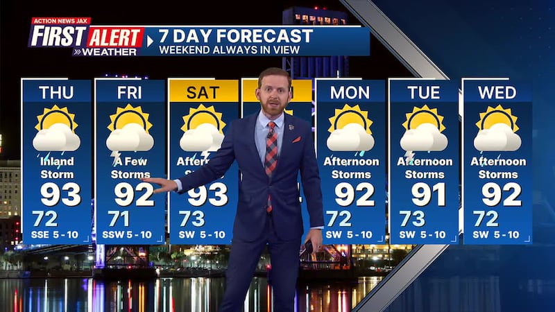
- A few mainly inland showers & storms Thu. & Fri. before afternoon storms become more widespread over the weekend.
- Hot & humid otherwise with highs 90-95 and lows 70-75.
TROPICS: No areas of concern. Next name: “Barry”. Always more: “Talking the Tropics With Mike”.
INTERACTIVE RADAR: Keep track of the rain as it moves through your neighborhood
WATCH THE FORECAST | DOWNLOAD THE APPS
First Alert 7-Day Forecast:
- TONIGHT: Partly cloudy with scattered SE Ga. t’storms overnight. Low: 72
- THURSDAY: Partly sunny with widely scattered inland afternoon t’storms. High: 93… 80s at the beaches.
- THURSDAY NIGHT: Inland storm early… partly cloudy. Low: 71
- FRIDAY: Partly sunny with scattered afternoon showers/t’storms. High: 92
- SATURDAY: Partly sunny with scattered afternoon showers/t’storms. 73/93
- SUNDAY: Partly sunny, scattered afternoon showers & t’storms. 71/94
- MONDAY: Partly sunny with scattered afternoon showers & t’storms 72/92
- TUESDAY: Partly sunny with scattered afternoon showers & storms. 73/91
- WEDNESDAY: Partly cloudy with scattered afternoon showers & t’storms. 72/92
Follow Action News Jax Meteorologists on Twitter for updates:
Mike Buresh | Garrett Bedenbaugh | Corey Simma | Trevor Gibbs
SHARE WITH US: Send us photos of the weather you’re seeing in your area ⬇️


