JACKSONVILLE, Fla. — The Action News Jax First Alert Weather Team has declared a First Alert Weather Day for Sunday and Monday.
Notes from the meteorologist:
- The weekend started out soaked for some
- Heavy rain & storms brought portions of Duval & St. Johns 1-2″ of rain
- There’s been a lull in the rain this afternoon with cloudy skies & mild temps
- More rain is on the way
- There will be a band of storms lifting up from Central FL that impacts NE FL from around 6-10 PM
- The next band of rain may set up north & west of Jax Sunday morning
- I’m also honing in on a line of storms moving across the entire area Sunday afternoon & evening
- Keep the umbrellas handy for Mother’s Day
- These bands continue off-and-on through the day on Monday
- We have a FIRST ALERT WEATHER DAY in effect through Monday because of these off-and-on storms
- The strongest storms will be capable of small hail & damaging winds
- Localized flooding is also a concern, with some spots having received 4-6″ of rain this week with more on the way
- Rain & storms go isolated/widely scattered on Tuesday
- Then we dry out and get HOT mid to late week
WATCH THE FORECAST | DOWNLOAD THE APPS
INTERACTIVE RADAR: Keep track of the rain as it moves through your neighborhood
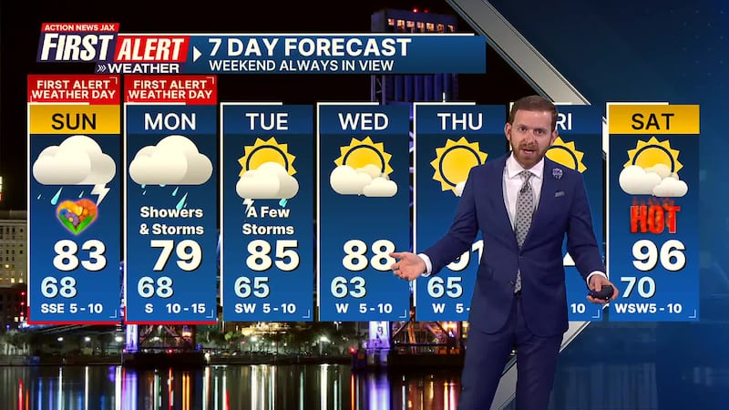
Here’s a look at your First Alert 7-Day Forecast:
- TONIGHT: Cloudy, A Few Showers & Storms. Low: 68
- TOMORROW: First Alert Weather Day. Off-and-On Rain & Storms. High: 83
- MON: First Alert Weather Day. Cloudy & Humid, Off-and-On Rain & Storms. 68/79
- TUE: Partly Cloudy, A Few Storms. 65/85
- WED: Partly Cloudy. 63/88
- THU: Mostly Sunny, Warming Up. 65/91
- FRI: Mostly Sunny. 69/94 (Record: 96 - 1995)
- SATon Partly Sunny. 70/96 (Record: 96 - 1995)
Follow Action News Jax Meteorologists on Twitter for updates:
Mike Buresh | Garrett Bedenbaugh | Corey Simma | Trevor Gibbs
SHARE WITH US: Send us photos of the weather you’re seeing in your area ⬇️


