JACKSONVILLE, Fla. — Here’s what the First Alert Weather Team said you can expect for the First Alert Weather forecast:
- It’s been a stormy afternoon in Duval
- Some spots in Western & Eastern Duval have gotten 1-2″ of rain
- A few showers continue late afternoon & evening west of I-95 & up in SE GA
- It should be a dry night for most with partly cloudy skies
- “Most” because we may have an isolated shower push up to I-75 from the Gulf tomorrow morning
- Sunday brings more of the same, mainly afternoon showers & storms
- Storm threat includes the beaches with southwesterly offshore winds
- This pattern continues each day next week
- The I-95 corridor out to the beaches will be the spots to watch each day for the strongest storms
- It’s early, but it sure looks like there will be storms on July Fourth afternoon
Tropics:
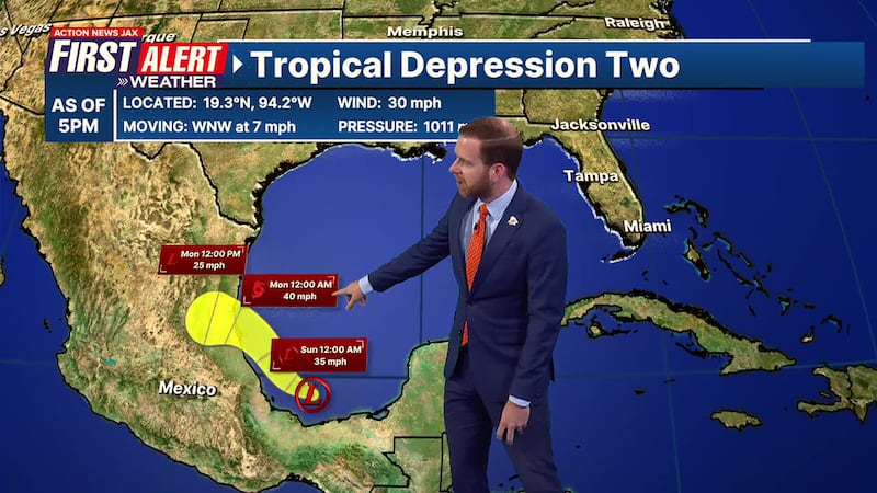
- Tropical Depression #2 has formed in the Southern Gulf
- It’s tracking toward the Gulf Coast of Central Mexico, away from Florida
- If it develops into a Tropical Storm, it will be “Barry,” and it will be short-lived
- This is not a concern for Florida or the U.S.
- There are no other areas of concern in the tropics
WATCH THE FORECAST | DOWNLOAD THE APPS
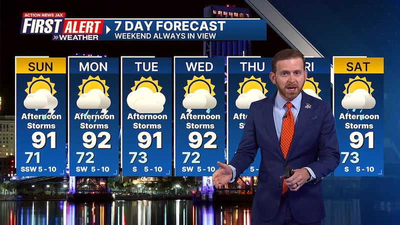
First Alert Weather 7-day forecast:
- TONIGHT: Partly Cloudy. Low: 71
- TOMORROW: Partly Cloudy, Scattered Storms. 71/91
- MON: Partly Sunny, Afternoon Storms. 72/92
- TUE: Partly Cloudy, Afternoon Storms. 73/91
- WED: Partly Sunny, Afternoon Storms. 72/92
- THU: Partly Cloudy, Afternoon Storms. 73/91
- JULY 4TH: Partly Sunny, Afternoon Storms. 72/91
- SAT: Partly Cloudy, Afternoon Storms. 73/91
WATCH THE FORECAST | DOWNLOAD THE APPS
Follow Action News Jax Meteorologists on Twitter for updates:
Mike Buresh | Garrett Bedenbaugh | Corey Simma | Trevor Gibbs
LISTEN: Mike Buresh ‘All the Weather, All the Time’ Podcast
INTERACTIVE RADAR: Keep track of the rain as it moves through your neighborhood
SHARE WITH US: Send us photos of the weather you’re seeing in your area ⬇️


