JACKSONVILLE, Fla. — Here’s what the First Alert Weather Team said you can expect for the First Alert Weather forecast:
- It’s another stormy afternoon, especially near I-95 and the beaches
- Some spots from Jax Beach to St. Aug and even down in Putnam County have 1-2″ of rain today
- Some neighborhoods are pushing half a foot of rain this week!
- A few isolated showers/storms may linger north & west of Jax before sunset
- Winds turn northeasterly on Monday, and rain/storms will push farther inland later in the day
- Onshore winds continue through Wednesday, focusing the heaviest rain & storms out toward I-75
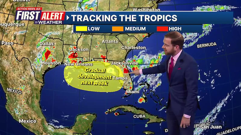
- A weak low-pressure will be moving over the local area in the first half of this week
- This low then drifts into the NE Gulf with low chances of developing into a tropical system
- This pattern will help guide showers & storms farther inland each day
- The heaviest rain will be between I-75 and the Gulf Coast
- There will still be showers & storms near the beaches & I-95, but it just won’t be as much
- The winds turn offshore by Friday, cranking our temps back up
WATCH THE FORECAST | DOWNLOAD THE APPS
TROPICS:
- The First Alert Weather Team is tracking low pressure drifting into the NE Gulf this week
- This does not appear to be a significant system
- Potential local impacts - if you can call them that - are detailed above
- The next named storm will be “Dexter”
Follow Action News Jax Meteorologists on Twitter for updates:
Mike Buresh | Garrett Bedenbaugh | Corey Simma | Trevor Gibbs
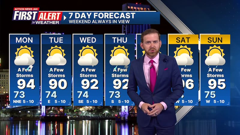
Take a look at our First Alert Weather 7-day forecast:
- TONIGHT: Partly Cloudy & Mild. Low: 73
- TOMORROW: Partly Cloudy & Hot, A Few Storms. High: 94
- TUE: Partly Sunny, A Few Storms Shifting Inland. 74/90
- WED: Partly Cloudy, A Few Inland Storms. 74/92
- THU: Partly Sunny, A Few Inland Storms. 73/92
- FRI: Partly Cloudy & Hot, A Few Storms. 74/95
- SAT: Partly Sunny, A Few Storms. 74/96
- SUN: Partly Cloudy, A Few Storms. 75/95
SHARE WITH US: Send us photos of the weather you’re seeing in your area ⬇️


