JACKSONVILLE, Fla. — A breezy morning with a few showers closer to the coast.
- High rip current risk once again at local beaches with surf 4-6 ft.
- Highs today will be in the mid 80s.
- Occasional showers moving off the Atlantic today from the coast to near or just west of the St. Johns River.
- A lot drier west of Highway 301 today.
- We gradually warm up through this week, back into the 90s by Friday and the weekend.
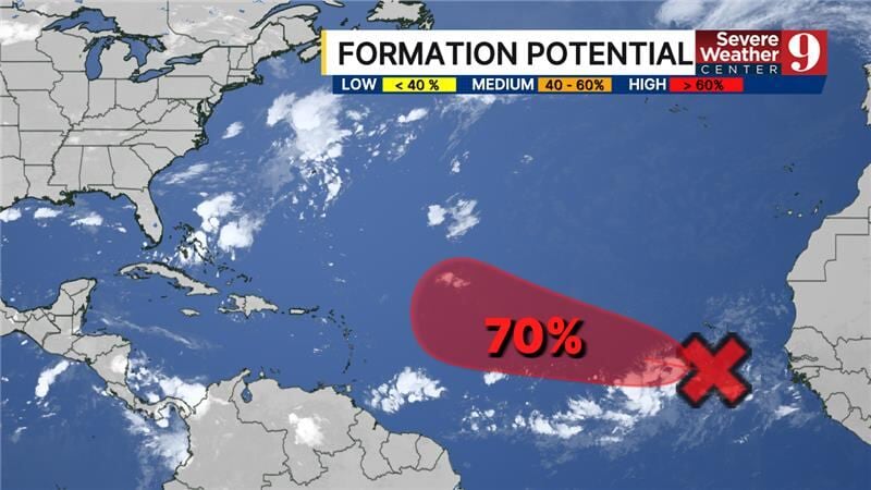
TROPICS:
- No active storms.
- A tropical wave has emerged off the coast of Africa and could develop in the long-range over the open ocean.
- The next name is Gabrielle.
TODAY: Partly to mostly cloudy with a few breezy showers, mainly in north Florida. HIGH: 86
TONIGHT: Partly cloudy with a few coastal showers. LOW: 70
WEDNESDAY: Partly cloudy with a few showers. 70/87
THURSDAY: Partly cloudy with an isolated shower. 71/89
FRIDAY: Partly to mostly sunny and warmer, isolated shower. 70/90
SATURDAY: Partly to mostly sunny and hot, isolated shower. 71/94
SUNDAY: Partly cloudy and hot with an isolated shower. 71/94
MONDAY: Partly cloudy with a few showers. 74/91

WATCH THE FORECAST | DOWNLOAD THE APPS
Follow Action News Jax Meteorologists on Twitter for updates:
Mike Buresh | Garrett Bedenbaugh | Corey Simma | Trevor Gibbs
ALLERGY TRACKER: See what the pollen counts look like in our area
LISTEN: Mike Buresh ‘All the Weather, All the Time’ Podcast
INTERACTIVE RADAR: Keep track of the rain as it moves through your neighborhood
SHARE WITH US: Send us photos of the weather you’re seeing in your area ⬇️


