JACKSONVILLE, Fla. — The First Alert Weather Team is tracking an evening end to Thursday’s storms before some more rain at times this 4th of July.
Notes from the meteorologist:
- Scattered storms will diminish early this evening, but not before some inland neighborhoods are soaked with 1-2 inches of rain.
- A pattern change begins Friday through the weekend. Winds blowing off the Atlantic will mean a few morning showers near the coast… then near I-95 midday with scattered showers & storms shifting well inland by late afternoon.
- Rain will be gone by fireworks time. There will be an increased rip current risk at area beaches. Highs will be in the 80s at the beaches to around 90 inland.
- It’s the same story Saturday. By Sunday, any showers will be isolated as high temps. return to the low 90s.
INTERACTIVE RADAR: Keep track of the rain as it moves through your neighborhood
WATCH THE FORECAST | DOWNLOAD THE APPS
TROPICS:
Now an orange (medium chance) offshore of Florida for tropical development over the weekend into early next week. The First Alert Weather Team remains unimpressed with any significant local impacts. IF low pressure does develop, the most likely scenario seems to point to a low northeast of Jacksonville moving away from the local area next week which may become a tropical depression. Rip current risk at area beaches. Always more: “Talking the Tropics With Mike”.
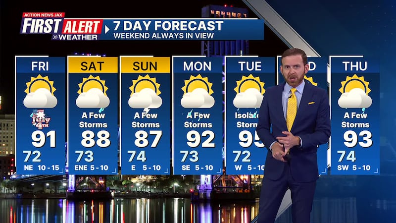
First Alert 7-Day Forecast:
- TONIGHT: Scattered evening showers & storms ending then partly cloudy. Low: 72
- 4TH OF JULY: Partly sunny with a few morning showers near the coast, then an afternoon inland shower or storm. High: 91
- FRIDAY NIGHT: Fair skies. Low: 73
- SATURDAY: Partly sunny with a few afternoon showers/t’storms shifting well inland by late afternoon. High: 88
- SUNDAY: Partly sunny with an isolated afternoon shower/t’storm. 74/91
- MONDAY: Partly sunny with isolated afternoon showers & t’storms. 73/92
- TUESDAY: Partly sunny with isolated afternoon showers & t’storms 72/95
- WEDNESDAY: Partly sunny with a few afternoon showers & storms. 74/94
- THURSDAY: Partly cloudy with a few afternoon showers & t’storms. 74/94
Follow Action News Jax Meteorologists on Twitter for updates:
Mike Buresh | Garrett Bedenbaugh | Corey Simma | Trevor Gibbs
SHARE WITH US: Send us photos of the weather you’re seeing in your area ⬇️


