JACKSONVILLE, Fla. — The First Alert Weather Team is tracking a brief moment of lower temperatures before another heating trend.
Notes from the meteorologist:
- With very humid air in place and a weak front nearby, a few showers and storms may redevelop into Tuesday. Otherwise, it will be partly cloudy with temperatures in the 70s & 80s.
- Showers and storms will blossom again Wednesday as temperatures heat through the 80s to near 90 with the focus for rain and storms shifting inland – west of I-95 – through the afternoon.
- Storms will become more widely scattered Thu./Fri. as temperatures return to the low to mid 90s.
- It will be even hotter for the weekend, with little rain expected as temperatures soar to near 100 degrees. Feels-like temperatures. will be 106-112 Saturday and Sunday and into early next week.
INTERACTIVE RADAR: Keep track of the rain as it moves through your neighborhood
Tropics
No areas of concern through the weekend. Always more: “Talking the Tropics With Mike”.
WATCH THE FORECAST | DOWNLOAD THE APPS
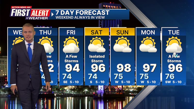
First Alert 7-Day Forecast
- TONIGHT: Scattered storms early… partly cloudy with an isolated shower or storm overnight. Low: 75
- WEDNESDAY: Scattered showers & storms developing… shifting inland through the afternoon. High: 90
- WEDNESDAY NIGHT: Evening shower/storm inland… partly cloudy. Low: 74
- THURSDAY: Partly sunny with a few inland afternoon showers & storms. High: 92
- FRIDAY: Partly sunny with a few inland showers & storms. 74/94
- SATURDAY: Partly sunny with an isolated storm. 74/96
- SUNDAY: Hot… mostly sunny. 75/98
- MONDAY: Hot… mostly sunny. 75/97
- TUESDAY: Partly sunny & hot with a few afternoon showers & t’storms. 76/96
Follow Action News Jax Meteorologists on Twitter for updates:
Mike Buresh | Garrett Bedenbaugh | Corey Simma | Trevor Gibbs
SHARE WITH US: Send us photos of the weather you’re seeing in your area ⬇️


