JACKSONVILLE, Fla. — The Action News Jax First Alert Weather Team is tracking scattered showers and storms ahead of the weekend.
Notes from the meteorologist:
- At least a couple rounds of showers & storms tonight.
- (1) widely scattered fast-moving showers & storms early this evening ending by at least sunset.
- (2) A line of showers & storms across Georgia will move south & east entering SE Ga. by 8-9pm & crossing into NE Fl. & Jacksonville about 10pm-midnight. Some of the storms will be heavy & a couple may become severe but with a general weakening trend late this evening.
- Saturday will begin with clouds, but much drier air will quickly move in, bringing sunshine & more comfortable temps.
- Highs Saturday & Sunday will be in the upper 80s while lows will fall well down into the 60s… even a few 50s north & west of Jacksonville!
INTERACTIVE RADAR: Keep track of the rain as it moves through your neighborhood
WATCH THE FORECAST | DOWNLOAD THE APPS
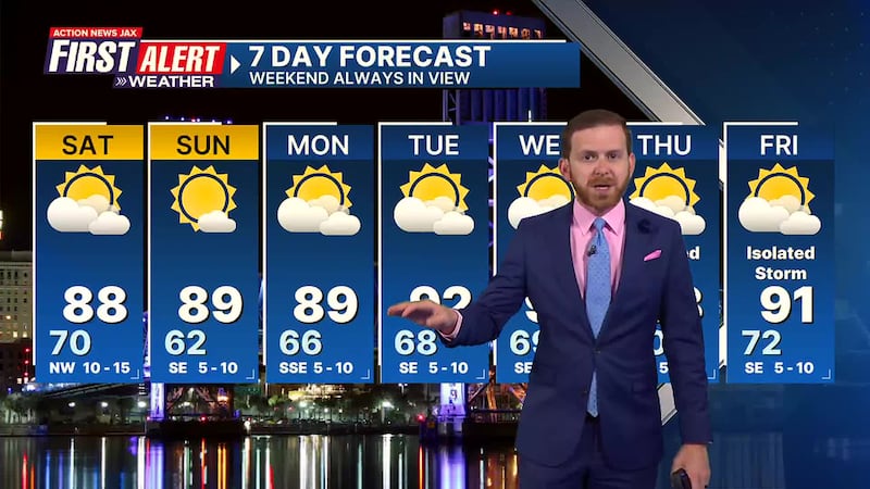
First Alert 7-Day Forecast:
- TONIGHT: Scattered showers & t’storms… ending north to south after midnight. Low: 70
- SATURDAY: Clouds early… a shower south… then clearing from northwest to southeast… less humid. High: 88
- SATURDAY NIGHT: Clear, nice & cool. Low: 62
- SUNDAY: Mostly sunny. & warm but low humidity. High: 89
- MONDAY: Partly sunny. 66/89
- TUESDAY: Partly sunny. 68/92
- WEDNESDAY: Partly sunny with an isolated shower. 69/92
- THURSDAY: Partly sunny with isolated shower/t’storm. 70/93
- FRIDAY: Partly sunny, with an isolated afternoon storm. 70/91
Follow Action News Jax Meteorologists on Twitter for updates:
Mike Buresh | Garrett Bedenbaugh | Corey Simma | Trevor Gibbs
SHARE WITH US: Send us photos of the weather you’re seeing in your area ⬇️


