JACKSONVILLE, Fla. — The Action News Jax First Alert Weather Team is tracking a nice night ahead, and a great opportunity to open up your windows.
Notes from the meteorologist:
- Lows will near 60 by morning inland, to the upper 60s at the coast.
- Friday will be warm but still with comfortable humidity as highs top out in the low 80s at the beaches to around 90 inland.
- The holiday weekend will become increasingly humid with highs in the upper 80s to low 90s. Saturday will be dry while an isolated storm may form late Sunday. But the vast majority of the day will remain dry.
- There will be a higher risk for a few afternoon thunderstorms on Memorial Day, but coverage still looks to be less than half the area as afternoon highs reach the low 90s with feel-like temperatures approaching 100 degrees.
ALLERGY TRACKER: See what the pollen counts look like in our area
WATCH THE FORECAST | DOWNLOAD THE APPS
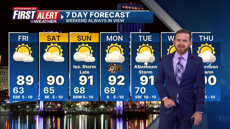
Here’s a look at your First Alert 7-Day Forecast:
- TONIGHT: Mostly clear & nice. Low: 63
- FRIDAY: Partly sunny & warm, but low humidity continues. High: 89
- FRIDAY NIGHT: Mostly clear & nice. Low: 65
- SATURDAY: Partly sunny. High: 90
- SUNDAY: Partly sunny, more humid… an isolated late-day storm. 68/91
- MEMORIAL DAY: Partly sunny with a few afternoon showers & t’storms. 69/92
- TUESDAY: Partly sunny with scattered afternoon storms. 70/91
- WEDNESDAY: Partly sunny with scattered afternoon showers/storms. 71/91
- THURSDAY: Partly sunny with scattered afternoon showers/t’storms. 71/90
Follow Action News Jax Meteorologists on Twitter for updates:
Mike Buresh | Garrett Bedenbaugh | Corey Simma | Trevor Gibbs


