JACKSONVILLE, Fla. — The First Alert Weather Team is tracking increasing thunderstorms along with continuing heat and humidity.
Notes from the meteorologist:
- Though locally heavy, there are only widely scattered storms into this evening with a slow drift to the east/northeast.
- Storm coverage looks more widespread Wednesday afternoon with some heavy downpours.
- The higher coverage of rain will continue into Thursday before becoming a little more widely scattered Friday into Saturday.
- The heat & humidity will continue, of course, only broken by the occasional showers & storms. Highs will generally reach the 90s with lows in the 70s.
WATCH THE FORECAST | DOWNLOAD THE APPS
INTERACTIVE RADAR: Keep track of the rain as it moves through your neighborhood
TROPICS
Quiet Atlantic Basin at the moment. Always more: “Talking the Tropics With Mike”.
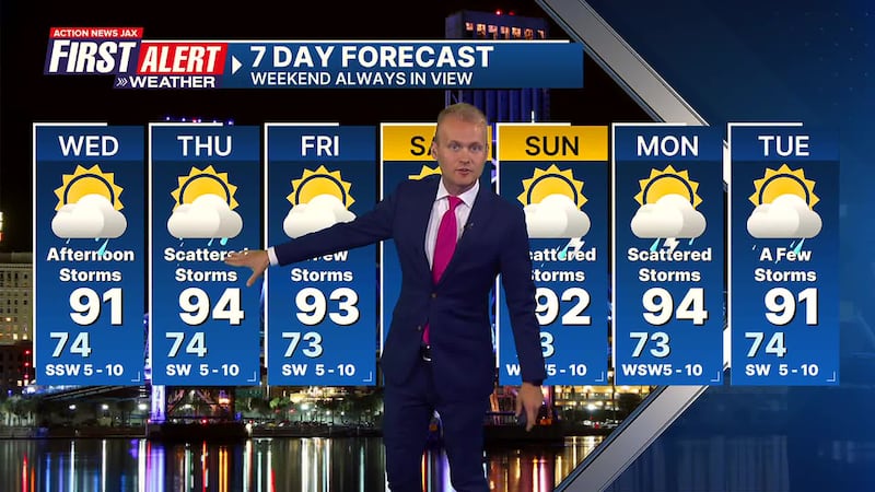
First Alert 7-Day Forecast
- TONIGHT: Widely scattered showers & storms early otherwise partly cloudy. Low: 74
- WEDNESDAY Partly sunny with afternoon t’storms. High: 91
- WEDNESDAY NIGHT: Evening scattered storms then partly cloudy. Low: 74
- THURSDAY: Partly sunny with scattered afternoon t’storm. High: 94
- FRIDAY: Partly sunny with a few afternoon shower/t’storm. 73/93
- SATURDAY: Partly sunny & hot with a few afternoon showers & t’storms. 74/93
- SUNDAY: Partly sunny with scattered afternoon showers & t’storms 73/92
- MONDAY: Partly sunny with scattered afternoon shower & storm. 73/94
- TUESDAY: Partly cloudy with a few afternoon showers & t’storms. 73/93
Follow Action News Jax Meteorologists on Twitter for updates:
Mike Buresh | Garrett Bedenbaugh | Corey Simma | Trevor Gibbs
SHARE WITH US: Send us photos of the weather you’re seeing in your area ⬇️