JACKSONVILLE, Fla. — The Action News Jax First Alert Weather team is tracking a mild Friday night with lows in the 60s under clear skies.
Notes from the meteorologist:
- The holiday weekend will be hot & humid with some risk for an afternoon storm so keep an eye to the sky.
- Saturday’s storm risk is primarily for Putnam & Southern St. Johns Co. Then isolated to widely scattered mainly inland – near & west of I-95 – Sunday afternoon through a few weakening cells could make it to the beaches by evening.
- A few afternoon storms will be possible just about anywhere on Memorial Day.
- Highs will be in the 80s at the beaches to the low to mid 90s inland.
- Sunburn time will be 10-15 minutes from 10am-4pm.
>>> STREAM ACTION NEWS JAX LIVE <<<
[DOWNLOAD: Free Action News Jax app for alerts as news breaks]
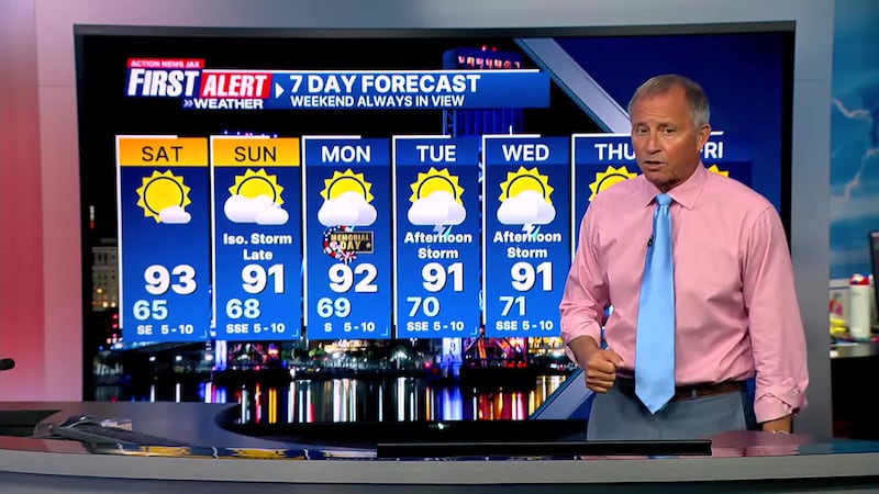
Here’s a look at your First Alert 7-Day Forecast:
- TONIGHT: Clear & mild. Low: 65
- SATURDAY: Partly sunny & hot… an isolated late day storm possible Putnam, S. St. Johns Co. High: 93
- SATURDAY NIGHT: Fair. Low: 68
- SUNDAY: Partly sunny, hot & humid with a widely scattered late day shower/t’storm. High: 92
- MEMORIAL DAY: Partly sunny with a few afternoon t’storms. 69/92
- TUESDAY: Partly sunny with scattered afternoon showers & t’storms. 70/91
- WEDNESDAY: Partly sunny with scattered afternoon storms. 71/91
- THURSDAY: Partly sunny with scattered afternoon showers/storms. 71/90
- FRIDAY: Partly sunny with scattered afternoon showers/t’storms. 72/90
[SIGN UP: Action News Jax Daily Headlines Newsletter]
Click here to download the free Action News Jax news and weather apps, click here to download the Action News Jax Now app for your smart TV and click here to stream Action News Jax live.


