JACKSONVILLE, Fla. — The first heat advisory of the year was issued Friday, lasting until 6 P.M., and more are expected this weekend.
First Alert Weather Forecast:
- Friday will see isolated evening showers and storms mainly inland. The rest of the night will be mostly clear and muggy.
- Saturday-Sunday will be the hottest weekend of the summer so far. Highs will top out 95-100 with feel-like temps. 104-110.
- Sunburn times will dip to 10 minutes or less from 10 am-4 pm. Sunscreen, shade & lots of water.
- Only isolated storms will develop in the afternoon with most areas staying dry.
- The middle and end of next week will see a return to daily afternoon storms and temperatures not *as* hot.
INTERACTIVE RADAR: Keep track of the rain as it moves through your neighborhood
ALLERGY TRACKER: See what the pollen counts look like in our area
Tropics
Temperatures are cookin’ but the tropics are not. Always more: “Talking the Tropics With Mike”.
WATCH THE FORECAST | DOWNLOAD THE APPS
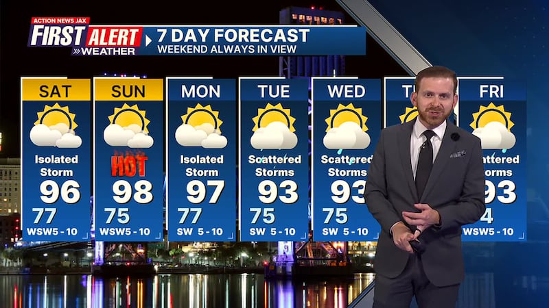
First Alert 7-Day Forecast
- TONIGHT: Scattered inland storms early then clearing. Low: 77
- SATURDAY Partly sunny with widely scattered afternoon t’storms. High: 96
- SATURDAY NIGHT: A storm early… mostly clear. Low: 75
- SUNDAY: Partly sunny & hot with an isolated afternoon storm. High: 98
- MONDAY: Hot.. partly sunny with an isolated afternoon shower/t’storm. 77/97
- TUESDAY: Hot… partly sunny with isolated afternoon showers & t’storms. 75/93
- WEDNESDAY: Partly sunny with a few afternoon showers & t’storms 75/93
- THURSDAY: Partly sunny with scattered afternoon showers & storms. 74/92
- FRIDAY: Partly cloudy with a few afternoon showers & t’storms. 74/91
Follow Action News Jax Meteorologists on Twitter for updates:
Mike Buresh | Garrett Bedenbaugh | Corey Simma | Trevor Gibbs
SHARE WITH US: Send us photos of the weather you’re seeing in your area ⬇️


