JACKSONVILLE, Fla. — The Action News Jax First Alert Weather Team is tracking a very hot and dry weekend.
There will be plenty of sunshine through the weekend with high temperatures in the 90s – including at the beaches. Lows will be in the upper 60s to around 70.
Sunburn times will be near 10 minutes from 10 am-4 pm – be careful!
There is a shot at an evening thunderstorm Sunday in SE Georgia, but it looks like NE Florida stays dry.
It’s dry and hot through the middle of next week before a cool front arrives Wednesday night with a shot at a scattered shower or storm. Cooler temperatures – finally! – happen Thursday & Friday next week.
ALLERGY TRACKER: See what the pollen counts look like in our area
LISTEN: Mike Buresh ‘All the Weather, All the Time’ Podcast
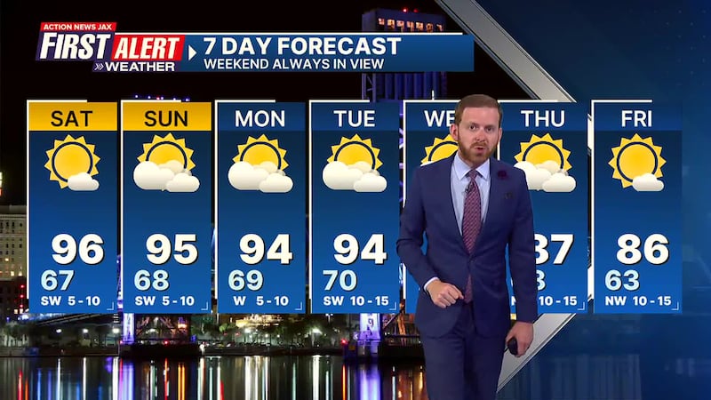
Here’s a look at your First Alert 7-Day Forecast:
- TONIGHT: Clear. Low: 67
- SATURDAY: Mostly sunny & hot. High: 96
- SATURDAY NIGHT: Mostly clear. Low: 68
- SUNDAY: Partly sunny & hot. High: 95
- MONDAY: Hot… partly sunny. 69/94
- TUESDAY: Partly sunny, hot. 70/94
- WEDNESDAY: Partly sunny, hot with a scattered evening shower or t’storm. 70/93
- THURSDAY: Partly sunny, not as hot. 68/87
- FRIDAY: Partly sunny. 63/86
WATCH THE FORECAST | DOWNLOAD THE APPS
Follow Action News Jax Meteorologists on Twitter for updates:
Mike Buresh | Garrett Bedenbaugh | Corey Simma | Trevor Gibbs


