JACKSONVILLE, Fla. — The Action News Jax First Alert Weather Team is tracking a mostly clear rest of the holiday weekend, before a hot, humid, and rainy stretch.
Only isolated showers or storms will develop Monday evening, moving toward the east between 5 and 9 pm or so.
Temperatures sit in the 90s inland and 85-90 at the beaches through sunset, before dropping to near 70 by sunrise.
The workweek will be hot under partly sunny skies with highs in the 90s.
Only isolated afternoon storms Tuesday will increase to widely scattered to scattered for Wednesday and Thursday.
An approaching cool front will increase rain & storm chances for Friday.
WATCH THE FORECAST | DOWNLOAD THE APPS
INTERACTIVE RADAR: Keep track of the rain as it moves through your neighborhood
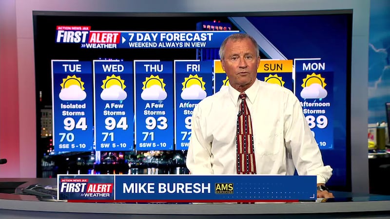
First Alert 7-Day Forecast:
- TONIGHT: Isolated shower/t’storm early… mostly clear overnight. Low: 70
- TUESDAY: Partly sunny, hot & humid with an isolated afternoon shower or t’storm. High: 94
- TUESDAY NIGHT: Fair. Low: 71
- WEDNESDAY: Partly sunny, hot & humid with a few scattered late day shower/t’storm. High: 94
- THURSDAY: Partly sunny with a few afternoon t’storms. 71/93
- FRIDAY: Partly sunny with afternoon showers & t’storms. 72/90
- SATURDAY: An isolated shower south of Jax otherwise partly to mostly sunny, cooler & less humid. 70/85
- SUNDAY: Partly sunny with an isolated afternoon shower or t’storm. 68/89
- MONDAY: Partly sunny with a few afternoon showers/t’storms. 69/89
Follow Action News Jax Meteorologists on Twitter for updates:
Mike Buresh | Garrett Bedenbaugh | Corey Simma | Trevor Gibbs


