Here’s what the First Alert Weather Team said you can expect for the First Alert Weather forecast:
WATCH THE FORECAST | DOWNLOAD THE APPS
- Monday was a drier day with only isolated thunderstorms across Southeast Georgia & St. Johns County in Northeast Florida that will dissipate by Monday evening.
- This week will be hot and humid with afternoon highs in the 90s and feel-like temperatures of 100-105 degrees.
- We will see isolated thunderstorms on Tuesday, followed by a gradual increase in storms each afternoon for the rest of the week.
ALLERGY TRACKER: See what the pollen counts look like in our area
TROPICS:
Chantal remnants will be moving offshore over the Western Atlantic and is not expected to redevelop. Otherwise quiet. Always more: “Talking the Tropics With Mike.”
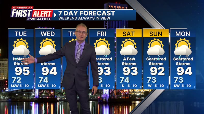
First Alert 7-Day Forecast
- TONIGHT: Isolated storms ending early otherwise partly cloudy. Low: 72
- TUESDAY Partly sunny & hot with isolated afternoon t’storms. High: 95
- TUESDAY NIGHT: Partly cloudy. Low: 74
- WEDNESDAY: Partly sunny with a few afternoon t’storm. High: 94
- THURSDAY: Partly sunny with a few afternoon shower/t’storm. 74/94
- FRIDAY: Partly sunny & hot with scattered afternoon showers & t’storms. 73/93
- SATURDAY: Partly sunny with a few afternoon showers & t’storms 74/93
- SUNDAY: Partly sunny with scattered afternoon shower & storm. 73/92
- MONDAY: Partly cloudy with scattered afternoon showers & t’storms. 73/94
Follow Action News Jax Meteorologists on Twitter for updates:
Mike Buresh | Garrett Bedenbaugh | Corey Simma | Trevor Gibbs
INTERACTIVE RADAR: Keep track of the rain as it moves through your neighborhood
SHARE WITH US: Send us photos of the weather you’re seeing in your area ⬇️