JACKSONVILLE, Fla. — The Action News Jax First Alert Weather Team is tracking a hot and humid Saturday with highs in the mid-90s and scattered afternoon and evening storms.
Notes from the First Alert Weather Team:
- A Heat Advisory will be in effect later today for our entire viewing area, as feels like temperatures climb near and above 108°F.
- Scattered showers and thunderstorms will develop this afternoon, initially along the I-95 corridor, then gradually shifting inland.
- Some storms will be heavy and slow-moving today, with very heavy rainfall leading to localized flooding. Frequent lightning is expected too in storms.
- Rain will end after sunset tonight inland, with some coastal showers/isolated storm possible early Sunday morning.
- More afternoon thunderstorms are expected Sunday, again shifting inland with time.
- The beaches are expected to see the least amount of rain this weekend, and west of the St. Johns River the most.
- Rip current risk this weekend: Low to moderate, unaffected by distant Hurricane Erin. Wave heights around 2 feet.
- Rip current risk quickly begins to rise Monday and especially Tuesday as swells from Hurricane Erin reach our coast. Dangerous, life-threatening rip currents are expected up and down our coast for several days next week, in addition to large breaking waves of generally 5-8′.
TROPICS:
- Hurricane Erin is rapidly intensifying on Saturday morning and is a major hurricane. As of the 11 a.m. advisory, Erin was upgraded to a Category 5.
- The core of Erin will safely pass north of Puerto Rico and the USVI, and a high confidence track of a path between the Bahamas and Bermuda. This keeps Erin far, far away from our local area.
- Erin will be a very large hurricane as it passes our latitude and will push strong swells toward our entire coastline, arriving Monday and lasting through around Thursday.
- Expect several days of dangerous rip currents and high surf of generally 5-8′ up and down our beaches. This may cause some minor beach erosion around the times of high tide.
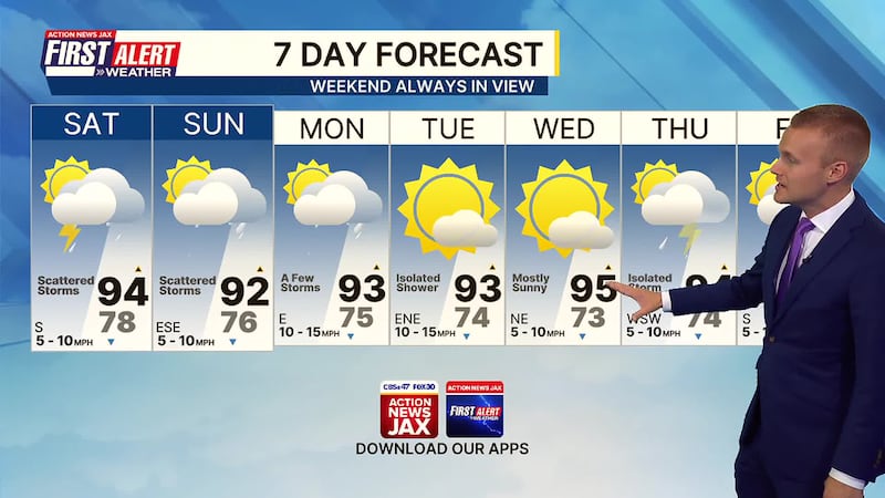
Take a look at the First Alert Weather Team 7-day forecast:
SATURDAY: Hot and humid with scattered afternoon/evening showers and storms. HIGH: 94
SATURDAY NIGHT: Rain inland early, warm and humid overnight with a few coastal showers after midnight. LOW: 76
SUNDAY: A few coastal showers early with inland afternoon showers and thunderstorms. 76/92
MONDAY: Partly cloudy with a few inland afternoon storms. 75/93
TUESDAY: Partly to mostly sunny with an isolated afternoon storm. 74/93
WEDNESDAY: Mostly sunny and hot. 73/95
THURSDAY: Partly to mostly sunny with an isolated afternoon storm. 74/94
FRIDAY: Partly cloudy with scattered afternoon storms. 75/94
WATCH THE FORECAST | DOWNLOAD THE APPS
Follow Action News Jax Meteorologists on Twitter for updates:
Mike Buresh | Garrett Bedenbaugh | Corey Simma | Trevor Gibbs
ALLERGY TRACKER: See what the pollen counts look like in our area
LISTEN: Mike Buresh ‘All the Weather, All the Time’ Podcast
INTERACTIVE RADAR: Keep track of the rain as it moves through your neighborhood
SHARE WITH US: Send us photos of the weather you’re seeing in your area ⬇️


