JACKSONVILLE, Fla. — Dry morning commute for Jacksonville.
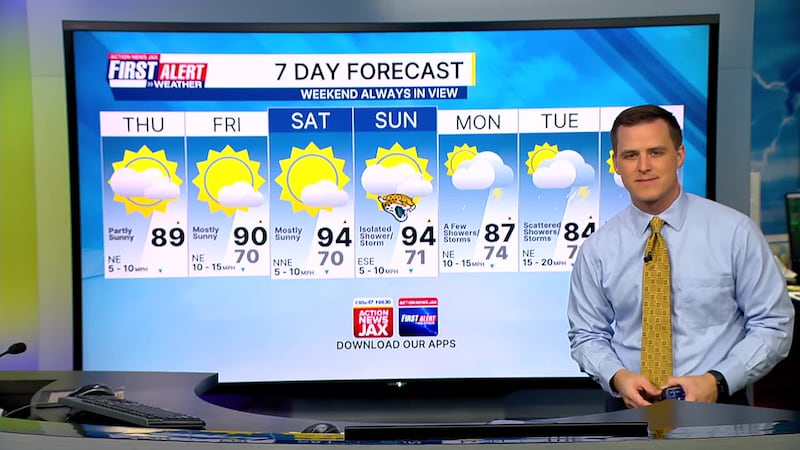
- Highs today will be in the upper 80s.
- A few neighborhoods west of Highway 301 should go just above 90 degrees today.
- Highs in the lower 90s over the weekend with only an isolated shower or storm on Sunday.
- Onshore winds return next week with scattered showers and highs back into the 80s.
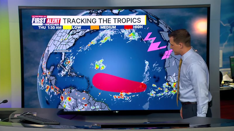
TROPICS:
- No active storms.
- A tropical wave continues to march west today across the Eastern Atlantic.
- Showers and storms will likely get more organized over the next day or two.
- A tropical depression or storm could form tomorrow or over the weekend.
- The next name is Gabrielle.
TODAY: Partly sunny and warm. HIGH: 89
TONIGHT: Mostly clear. LOW: 70
FRIDAY: Partly to mostly sunny and warmer. 70/90
SATURDAY: Partly to mostly sunny and hot. 71/94
SUNDAY: Partly cloudy and hot with an isolated shower/storm. 71/94
MONDAY: Mostly cloudy with scattered showers/storms. Turning breezy. 74/87
TUESDAY: Mostly cloudy with scattered showers/storms. Breezy. 71/84
WEDNESDAY: Mostly cloudy with a few showers. Breezy. 70/83
WATCH THE FORECAST | DOWNLOAD THE APPS
Follow Action News Jax Meteorologists on Twitter for updates:
Mike Buresh | Garrett Bedenbaugh | Corey Simma | Trevor Gibbs
ALLERGY TRACKER: See what the pollen counts look like in our area
LISTEN: Mike Buresh ‘All the Weather, All the Time’ Podcast
INTERACTIVE RADAR: Keep track of the rain as it moves through your neighborhood
SHARE WITH US: Send us photos of the weather you’re seeing in your area ⬇️


