The Action News Jax First Alert Weather Team is tracking more hot days ahead and a mostly dry night.
INTERACTIVE RADAR: Keep track of the rain as it moves through your neighborhood
Notes from the meteorologist:
- It’s just the latest sunny & hot day, JIA topped out at 95 degrees
- A small band of storms pushed through SE GA earlier this afternoon
- The Golden Isles Air Show was cancelled due to the strong storms
- Some spots got just under a half-inch of rain
- There may be an isolated shower near & north of I-10 tonight, but most spots stay dry
- The weather stays quiet & hot Monday & Tuesday with near record highs
- A weak cold front moves in Wednesday, bringing a low chance for rain & storms
- Temps slightly cool down into the 80s late week & next weekend
- Long-range forecast scenarios hint at some rain next weekend, but that’s still TBD
- Morning temps look comfortable late week, potentially the coolest mornings we’ll have until the Fall
WATCH THE FORECAST | DOWNLOAD THE APPS
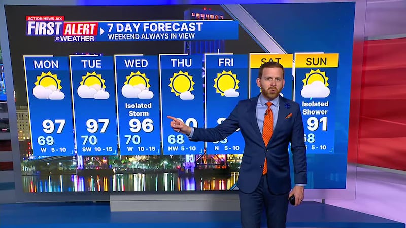
Here’s a look at your First Alert 7-Day Forecast:
- TONIGHT: Partly Cloudy & Mild. Iso. Inland Shower. Low: 69
- TOMORROW: Partly Sunny & Hot. High: 97 (Record: 97 - 1960)
- TUE: Partly Sunny. 70/97 (Record: 99 - 1962)
- WED: Partly Cloudy, Isolated Shower/Storm. 70/96 (Record: 99 - 1938)
- THU: Mostly Sunny. 68/90
- FRI: Mostly Sunny. 63/89
- SAT: Mostly Sunny. 62/87
- SUN: Mostly Sunny, Isolated Showers. 68/91
ALLERGY TRACKER: See what the pollen counts look like in our area


