JACKSONVILLE, Fla. — Tracking a dry morning commute.
- Hot afternoon with highs in the lower 90s and feels like temperatures 100+.
- A few late afternoon showers/storms well inland.
- Locally heavy downpours and lightning are the main threats.
- Moderate rip current risk at local beaches today.
- The heat cranks up as we head into the weekend.
- Highs on Saturday and Sunday will be in the mid to upper 90s with feels like temps. 105+.
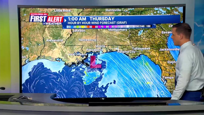
TROPICS
- The First Alert Weather Team is tracking low pressure moving across the Western Panhandle of Florida.
- Some possibility of development as it approaches Louisiana tomorrow if it can move into the Gulf.
- The next named storm will be “Dexter”
- More details: Talking the Tropics with Mike
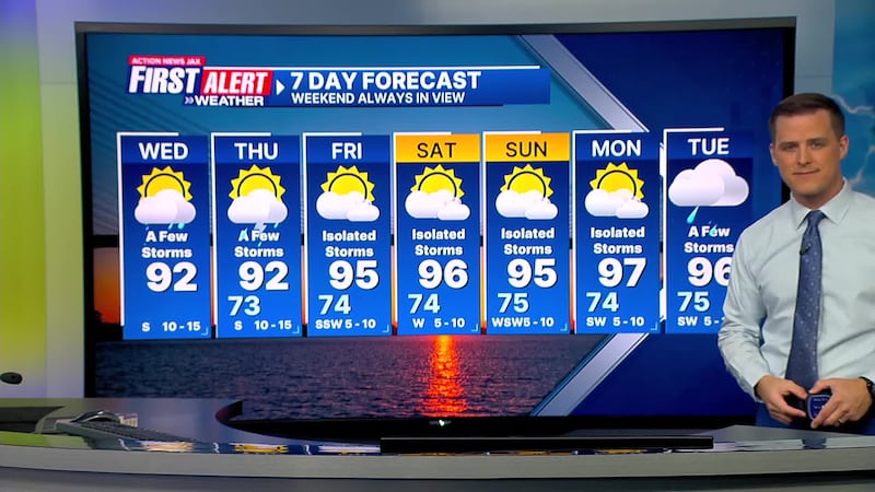
TODAY: Partly cloudy, a few late afternoon showers/storms. High: 92 (Feels like: 101+)
TONIGHT: Partly cloudy. Isolated shower early. Low: 73
THURSDAY: Partly sunny, a few inland storms. 73/92
FRIDAY: Partly cloudy & hot, isolated afternoon storms. 74/95
SATURDAY: Partly sunny, isolated afternoon shower/storm. 74/96
SUNDAY: Partly sunny and hot. Isolated afternoon storm. 75/95
MONDAY: Partly sunny and hot. Isolated afternoon storm. 74/97
TUESDAY: Partly sunny and hot. A few afternoon storms. 75/96
>>> STREAM ACTION NEWS JAX LIVE <<<
[DOWNLOAD: Free Action News Jax app for alerts as news breaks]
[SIGN UP: Action News Jax Daily Headlines Newsletter]
Click here to download the free Action News Jax news and weather apps, click here to download the Action News Jax Now app for your smart TV and click here to stream Action News Jax live.