JACKSONVILLE, Fla. — This morning is once again warm and humid with temperatures in the upper 70s/low 80s.
- Highs today will reach the lower and middle 90s with peak feels like temperatures 100-105F (heat advisory begins at 108F, so no heat alerts in place).
- Like yesterday, rain and storm coverage will be greatest in SE GA and will still be hit-or-miss. Many neighborhoods, especially across NE FL, look to stay mostly dry today.
- Storms that do form will be capable of brief torrential rain, strong gusty winds, and frequent lightning.
- Storm coverage ramps up beginning Tuesday across the area with daily rounds of rain continuing through the rest of the week.
- Wednesday and Thursday look to feature the most storms across our area with an active sea breeze.
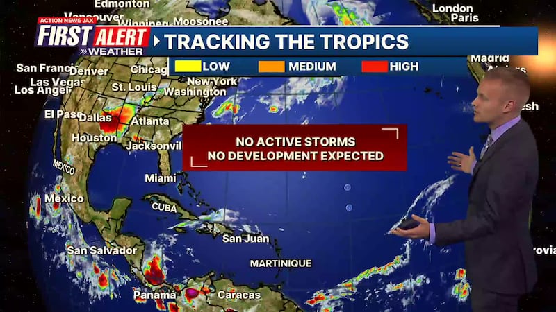
TROPICS:
- All is quiet in the Atlantic.
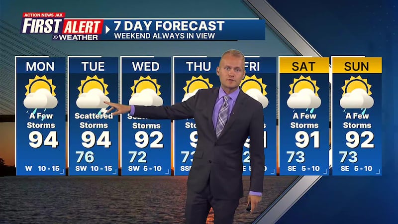
TODAY: Hot & humid with a few storms, especially in GA. HIGH: 94
TONIGHT: Partly cloudy and humid with an isolated storm. LOW: 76
TUESDAY: Partly cloudy with widely scattered storms. 76/94
WEDNESDAY: Partly cloudy with scattered storms. 72/92
THURSDAY: Partly cloudy with scattered storms. 73/91
FRIDAY: Partly cloudy with a few storms. 72/91
SATURDAY: Partly cloudy with a few storms. 73/91
SUNDAY: Partly cloudy with a few storms. 73/92
>>> STREAM ACTION NEWS JAX LIVE <<<
[DOWNLOAD: Free Action News Jax app for alerts as news breaks]
[SIGN UP: Action News Jax Daily Headlines Newsletter]
Click here to download the free Action News Jax news and weather apps, click here to download the Action News Jax Now app for your smart TV and click here to stream Action News Jax live.


