JACKSONVILLE, Fla. — We are tracking a few coastal storms this morning moving generally south.
- Some wet roads along the immediate coastline.
- A few showers and storms redevelop this afternoon and head inland.
- A strong storm is possible as well.
- Impacts: locally heavy rainfall, frequent lightning and gusty winds.
- Localized flooding is possible with any slow moving storms.
- Highs in the lower to mid 90s today. Feels like temperatures 100-105.
- Weak low pressure will be moving from the Atlantic to our south tomorrow.
- This low then drifts into the NE Gulf with some possibility of developing into a tropical system
- This pattern will help guide showers & storms farther inland each day
- The heaviest rain will be between I-75 and the Gulf Coast
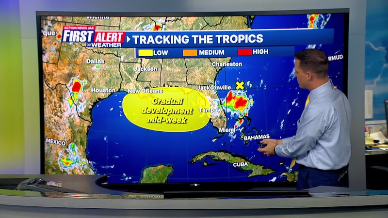
TROPICS
- The First Alert Weather Team is tracking low pressure in the Atlantic drifting into the NE Gulf early this week
- The next named storm will be “Dexter”
- More details: Talking the Tropics with Mike
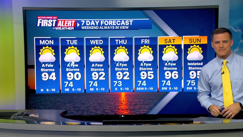
TODAY: Partly cloudy & hot, a few storms. High: 94
TONIGHT: Partly cloudy. Isolated shower. Low: 74
TUESDAY: Partly sunny, a few storms shifting inland. 74/90
WEDNESDAY: Partly cloudy, a few inland storms. 74/92
THURSDAY: Partly sunny, a few inland storms. 73/92
FRIDAY: Partly cloudy & hot, a few storms. 74/95
SATURDAY: Partly sunny, a few storms. 74/96
SUNDAY: Partly sunny and hot. Isolated afternoon storm. 75/95
>>> STREAM ACTION NEWS JAX LIVE <<<
[DOWNLOAD: Free Action News Jax app for alerts as news breaks]
[SIGN UP: Action News Jax Daily Headlines Newsletter]
Click here to download the free Action News Jax news and weather apps, click here to download the Action News Jax Now app for your smart TV and click here to stream Action News Jax live.


