JACKSONVILLE, Fla. — The First Alert Weather Team is tracking evening storms well inland that will end early, as well as some potential for activity in the tropics.
- Tracking low pressure near Florida that could become a tropical disturbance while moving away **
- Low pressure is east of Florida & will move west across the state through Tue., then over the Gulf where some tropical development will be possible.
- Few local impacts other then a few showers & storms. Impacts – heavy rain & a rip current risk – will be greater along the west coast of Fl., the Panhandle & along the Gulf Coast.
- Otherwise – locally – this week will be hot & humid with a few showers & thunderstorms each day. Highs will be in the 90s but a bit lower at the beaches thanks to a sea breeze.
- Next name: “Dexter”.
- Always more: “Talking the Tropics With Mike”.
INTERACTIVE RADAR: Keep track of the rain as it moves through your neighborhood
WATCH THE FORECAST | DOWNLOAD THE APPS
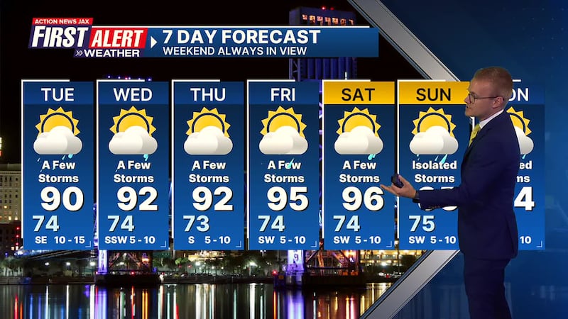
First Alert 7-Day Forecast
- TONIGHT: Aside from early evening storms, mostly clear with a shower possible toward morning near the coast. Low: 74
- TUESDAY: Partly sunny with a few showers & t’storms. High: 90
- TUESDAY NIGHT: An evening shower/storm… partly cloudy. Low: 74
- WEDNESDAY: Partly sunny with a few showers/ t’storms. High: 92
- THURSDAY: Partly sunny with a few afternoon shower/t’storms. 73/92
- FRIDAY: Partly sunny with a few afternoon showers & t’storms. 74/95
- SATURDAY: Partly sunny with a few afternoon showers & t’storms. 74/96
- SUNDAY: Partly sunny with an isolated shower & storm. 74/94
- MONDAY: Partly cloudy with isolated showers & t’storms. 74/92
Follow Action News Jax Meteorologists on Twitter for updates:
Mike Buresh | Garrett Bedenbaugh | Corey Simma | Trevor Gibbs
SHARE WITH US: Send us photos of the weather you’re seeing in your area ⬇️


