JACKSONVILLE, Fla. — This First Alert Weather Day, our meteorologists continue to track rain and potentially severe weather in our area.
Notes from the First Alert Weather Team:
- The rain continues on Mother’s Day
- Bands of rain & storms have been heaviest north & west of Jax through Sunday morning & afternoon
- We await the next bands of rain over the next several hours
- Monday will feature more rain & storms at times
- There will be some lulls in the activity, though
- Keep an eye to the sky & keep the umbrella handy
- Tuesday, we’ll finally see some sunshine & warmer temps
- There will still be a few showers & storms midday & afternoon Tuesday
- The main storm system responsible for all the rain lately lifts away Tuesday-Wednesday
- Then we dry out and heat up big-time mid to late week
- Daytime highs will be well into the 90s with some spots - dare I say - approaching 100
INTERACTIVE RADAR: Keep track of the rain as it moves through your neighborhood
WATCH THE FORECAST | DOWNLOAD THE APPS
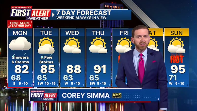
Here’s a look at the First Alert 7-Day Forecast:
- TONIGHT: Off-and-On Showers. Low: 68
- TOMORROW: First Alert Weather Day. Bands of heavy rain & storms at times. High: 82
- TUE: Partly Sunny, A Few Midday & Afternoon Storms. 65/85
- WED: Partly Sunny. 63/88
- THU: Partly Cloudy. 65/91
- FRI: Partly Sunny & Hot! 69/94 (Record: 96 - 1995)
- SAT: Partly Cloudy. 70/96 (Record: 96 - 1995)
- SUN: Partly Sunny. 71/95 (Record: 96 - 1899)
Follow Action News Jax Meteorologists on Twitter for updates:
Mike Buresh | Garrett Bedenbaugh | Corey Simma | Trevor Gibbs
SHARE WITH US: Send us photos of the weather you’re seeing in your area ⬇️


