JACKSONVILLE, Fla. — Clouds will be on the increase late this morning in Jacksonville.
- Winds will be out of the SW at 10-20 mph.
- Highs today will be in the lower to mid 80s in NE Florida and in the 70s in SE Georgia.
- Pine/Cedar pollen in full swing. Oak spreading north as well in Jacksonville.
- A strong cold front will arrive this afternoon and evening bringing scattered showers and even a few rumbles of thunder (especially north and west of Jacksonville.
- The arrival timing for today’s rain in Jacksonville is between 1 and 3 p.m.
- A few storms producing gusty winds will arrive in Inland SE Georgia between 11 a.m. and Noon.
- Winds in Georgia could reach 40-60 mph along the leading edge of the line of storms.
- Showers and storms will generally weaken as they move in NE Florida.
- We will remain cloudy for Valentine’s Day with highs just in the 60s.
>>> STREAM ACTION NEWS JAX LIVE <<<
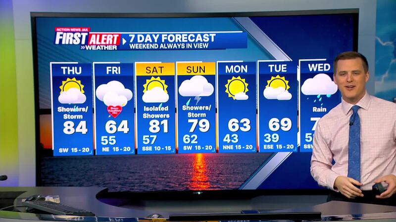
TODAY: Partly to Mostly Cloudy, Showers arrive in the afternoon / isolated storm. High: 84 (Record: 89 - 2020)
TONIGHT: Partly cloudy. Low: 62
VALENTINE’S DAY: Cloudy, breezy and cooly. 55/64
SATURDAY: Partly cloudy and warm. Widely scattered afternoon shower possible. 57/81
SUNDAY: Breezy & humid, Scattered showers/storm in the afternoon. 62/79
MONDAY: Turning mostly sunny and cooler. 43/63
TUESDAY: Mostly sunny. 39/65
WEDNESDAY: Cloudy with rain developing. 53/73
[DOWNLOAD: Free Action News Jax app for alerts as news breaks]
[SIGN UP: Action News Jax Daily Headlines Newsletter]
Click here to download the free Action News Jax news and weather apps, click here to download the Action News Jax Now app for your smart TV and click here to stream Action News Jax live.


