JACKSONVILLE, Fla. — The Action News Jax First Alert Weather Team is tracking a warm and humid day, with feels-like temperatures rising into the 100s this afternoon.
Notes from the meteorologist:
- This morning’s temperatures are near 80 degrees under partly cloudy skies.
- High temperatures will reach the mid-90s today with maximum feels-like temperatures of 102- 106°F. No heat alerts are in effect (that begins at 108F).
- The first half of the day will remain dry with spotty coverage of showers and an isolated storm developing by the early-middle afternoon.
- More substantial thunderstorms will sweep across southeast GA by the middle afternoon, pushing into northeast FL and weakening by the early evening. These storms could contain some damaging wind gusts in GA, along with heavy rains and frequent lightning. It is possible the storms dissipate altogether as they enter FL.
- More afternoon thunderstorms are expected amidst the hot and humid air each day over the next week.
Tropics:
- No active storms in the Atlantic.
INTERACTIVE RADAR: Keep track of the rain as it moves through your neighborhood
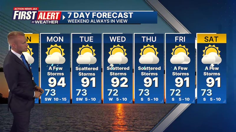
First Alert 7-Day Forecast:
- TODAY: Hot & humid with a few afternoon/evening storms. HIGH: 94
- TONIGHT: Partly cloudy and humid. LOW: 73
- MONDAY: Hot & humid with a few afternoon/evening storms. 73/94
- TUESDAY: Partly cloudy with scattered storms. 73/91
- WEDNESDAY: Partly cloudy with scattered storms. 72/92
- THURSDAY: Partly cloudy with scattered storms. 73/91
- FRIDAY: Partly cloudy with a few storms. 72/91
- SATURDAY: Partly cloudy with a few storms.73/91
Follow Action News Jax Meteorologists on Twitter for updates:
Mike Buresh | Garrett Bedenbaugh | Corey Simma | Trevor Gibbs
LISTEN: Mike Buresh ‘All the Weather, All the Time’ Podcast
SHARE WITH US: Send us photos of the weather you’re seeing in your area ⬇️


