The First Alert Weather Team is tracking continuing scattered storms, especially inland this evening, before things turn partly cloudy.
Notes from the meteorologist:
- Afternoon storms will erupt across much of the area Wed. & again Thu. with locally heavy downpours, gusty winds & a good amount of lightning.
- Storms become more widely scattered for the 4th of July through the weekend.
- Otherwise, seasonally hot temps. can be expected with highs in the upper 80s to low 90s & lows 70-75.
INTERACTIVE RADAR: Keep track of the rain as it moves through your neighborhood
TROPICS: Still a yellow (low chance) shading over & near Florida for tropical development. The First Alert Weather Team remains unimpressed with any local impacts. IF low pressure does develop, the most likely scenario seems to point to a low northeast of Jacksonville moving away from the local area. Always more: “Talking the Tropics With Mike”.
WATCH THE FORECAST | DOWNLOAD THE APPS
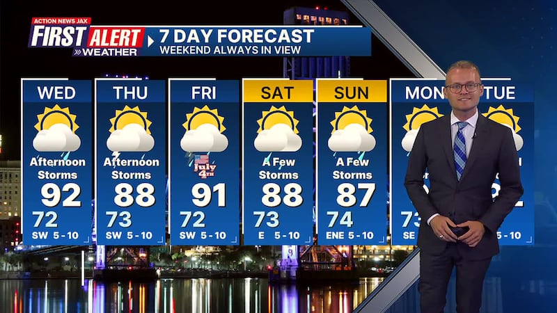
First Alert 7-Day Forecast:
- TONIGHT: A few evening showers & storms then partly cloudy. Low: 72
- WEDNESDAY: Partly sunny with afternoon showers/t’storms. High: 92
- WEDNESDAY NIGHT: A shower/storm early… partly cloudy. Low: 73
- THURSDAY: Partly sunny with afternoon showers/t’storms. High: 88
- INDEPENDENCE DAY: Partly sunny with a few afternoon showers/t’storms. 72/91
- SATURDAY: Partly sunny with a few afternoon showers & t’storms. 73/88
- SUNDAY: Partly sunny with a few afternoon showers & t’storms 74/87
- MONDAY: Partly sunny with a few afternoon showers & storms. 73/92
- TUESDAY: Partly cloudy with isolated afternoon showers & t’storms. 72/92
Follow Action News Jax Meteorologists on Twitter for updates:
Mike Buresh | Garrett Bedenbaugh | Corey Simma | Trevor Gibbs
SHARE WITH US: Send us photos of the weather you’re seeing in your area ⬇️


