JACKSONVILLE, Fla. — The Action News Jax First Alert Weather Team is tracking a hot weather Saturday, with temps reaching the upper 90s and feeling even hotter.
Notes from the First Alert Weather Team:
- Temperatures on Saturday will rise into the middle and upper 90s with feels-like temperatures approaching 110°F.
- A Heat Advisory is in effect for all of north Florida and coastal southeast Georgia.
- An isolated shower/storm is possible Saturday afternoon, but most areas will remain dry. The entire area is expected to be dry on Sunday.
- Very hot weather continues Sunday and Monday, with rain starting to help cool things down into next week.
- Rain chances return Monday afternoon, with higher coverage later in the week. Several inches of rain are likely next week.
TROPICS:
- No active storms.
- A tropical wave is moving through the open Atlantic toward the eastern Caribbean. There is a low chance this develops into something tropical over the next week.
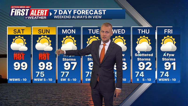
Take a look at the First Alert Weather Team 7-day forecast:
SATURDAY: Very hot with an isolated afternoon storm. HIGH: 99 (Record: 101 - 2000)
SATURDAY NIGHT: Partly cloudy and warm. LOW: 75
SUNDAY: Partly to mostly sunny and very hot. 75/98 (Record: 103 - 2000)
MONDAY: Partly cloudy and hot with a few afternoon storms. 77/97
TUESDAY: Partly cloudy with scattered afternoon storms. 75/93
WEDNESDAY: Partly cloudy with a few afternoon storms. 75/93
THURSDAY: Partly cloudy with scattered afternoon storms. 74/92
FRIDAY: Partly cloudy with a few afternoon storms. 74/93
WATCH THE FORECAST | DOWNLOAD THE APPS
ALLERGY TRACKER: See what the pollen counts look like in our area
LISTEN: Mike Buresh ‘All the Weather, All the Time’ Podcast
INTERACTIVE RADAR: Keep track of the rain as it moves through your neighborhood
SHARE WITH US: Send us photos of the weather you’re seeing in your area ⬇️


