JACKSONVILLE, Fla. — Here’s what the First Alert Weather Team said you can expect for the First Alert Weather forecast:
- Even into this evening, feels like temps will stay in the 90s through around 8-9 PM
- Tomorrow’s just like today - sunny & very hot
- There may be an isolated shower in NE FL, but most spots will be bone dry
- Monday brings a better chance for afternoon storms
- But temps stay between 95-100 on Monday afternoon
- The faucet really turns back on Tue-Thu of next week
- With scattered showers & storms, temps won’t be quite as hot
- It will still be very humid each day to go with the threat for storms
- We may see another drying trend into next weekend with high pressure building back
WATCH THE FORECAST | DOWNLOAD THE APPS
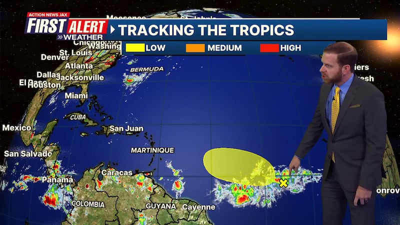
TROPICS
- The National Hurricane Center has highlighted a tropical wave in the Atlantic
- This thing is in the middle of nowhere, halfway between Africa and South America
- This thing may try to develop over the next day or two
- If it does, it will be short-lived - there’s shear & dry air closer to the Caribbean & West Atlantic
- Next named storm is “Dexter”
Follow Action News Jax Meteorologists on Twitter for updates:
Mike Buresh | Garrett Bedenbaugh | Corey Simma | Trevor Gibbs
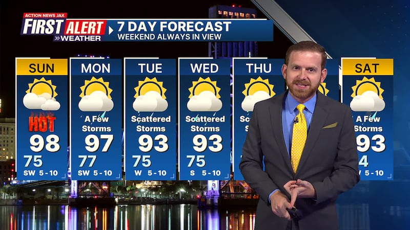
Take a look at the First Alert Weather Team 7-day forecast:
- TONIGHT: Humid & Warm. Low: 75
- TOMORROW: Partly to Mostly Sunny, Very Hot. High: 98
- MON: Partly Cloudy & Hot, A Few Storms. 77/97
- TUE: Partly Cloudy, Scattered Showers & Storms. 75/93
- WED: Scattered Showers & Storms. 75/93
- THU: Scattered Showers & Storms. 74/92
- FRI: Partly Cloudy, A Few Storms. 74/91
- SAT: Partly Sunny, A Few Storms. 74/93
SHARE WITH US: Send us photos of the weather you’re seeing in your area ⬇️